You are here: Home > Network List > IU - Global Seismograph Network (GSN - IRIS/USGS) Stations List
> Station GUMO Guam, Marianas Islands > Earthquake Result Viewer
GUMO Guam, Marianas Islands - Earthquake Result Viewer
| Earthquake location: |
Southwest Indian Ridge |
| Earthquake latitude/longitude: |
-28.8/61.7 |
| Earthquake time(UTC): |
2006/08/16 (228) 18:39:00 GMT |
| Earthquake Depth: |
13 km |
| Earthquake Magnitude: |
5.6 MB, 5.3 MS, 5.9 MW, 5.7 MW |
| Earthquake Catalog/Contributor: |
WHDF/NEIC |
|
| Network: |
IU Global Seismograph Network (GSN - IRIS/USGS) |
| Station: |
GUMO Guam, Marianas Islands |
| Lat/Lon: |
13.59 N/144.87 E |
| Elevation: |
14 m |
|
| Distance: |
90.6 deg |
| Az: |
74.891 deg |
| Baz: |
240.605 deg |
| Ray Param: |
0.041663773 |
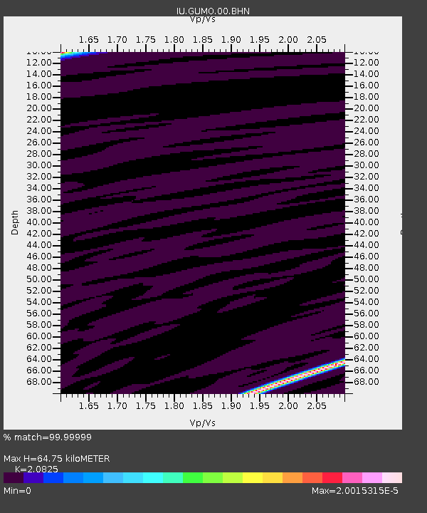
| Estimated Moho Depth: |
64.75 km |
| Estimated Crust Vp/Vs: |
2.08 |
| Assumed Crust Vp: |
4.802 km/s |
| Estimated Crust Vs: |
2.306 km/s |
| Estimated Crust Poisson's Ratio: |
0.35 |
|
| Radial Match: |
99.99999 % |
| Radial Bump: |
2 |
| Transverse Match: |
99.99998 % |
| Transverse Bump: |
2 |
| SOD ConfigId: |
2564 |
| Insert Time: |
2010-03-03 14:39:35.413 +0000 |
| GWidth: |
2.5 |
| Max Bumps: |
400 |
| Tol: |
0.001 |
|
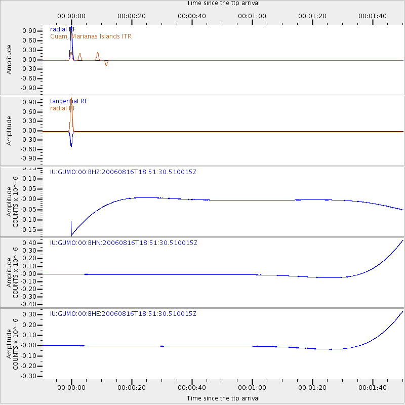
Signal To Noise
| Channel | StoN | STA | LTA |
| IU:GUMO:00:BHN:20060816T18:51:30.510015Z | 0.9111153 | 3.3844408E-8 | 3.7146133E-8 |
| IU:GUMO:00:BHE:20060816T18:51:30.510015Z | 0.9097818 | 2.5620107E-8 | 2.8160715E-8 |
| IU:GUMO:00:BHZ:20060816T18:51:30.510015Z | 0.90328574 | 4.9035528E-8 | 5.428573E-8 |
| Arrivals |
| Ps | 15 SECOND |
| PpPs | 41 SECOND |
| PsPs/PpSs | 56 SECOND |


