You are here: Home > Network List > IU - Global Seismograph Network (GSN - IRIS/USGS) Stations List
> Station GUMO Guam, Marianas Islands > Earthquake Result Viewer
GUMO Guam, Marianas Islands - Earthquake Result Viewer
| Earthquake location: |
Eastern Kashmir |
| Earthquake latitude/longitude: |
35.5/78.2 |
| Earthquake time(UTC): |
2006/09/11 (254) 18:12:22 GMT |
| Earthquake Depth: |
15 km |
| Earthquake Magnitude: |
5.5 MB, 5.1 MS, 5.4 MW, 5.3 MW |
| Earthquake Catalog/Contributor: |
WHDF/NEIC |
|
| Network: |
IU Global Seismograph Network (GSN - IRIS/USGS) |
| Station: |
GUMO Guam, Marianas Islands |
| Lat/Lon: |
13.59 N/144.87 E |
| Elevation: |
14 m |
|
| Distance: |
63.3 deg |
| Az: |
92.065 deg |
| Baz: |
302.978 deg |
| Ray Param: |
0.059665512 |
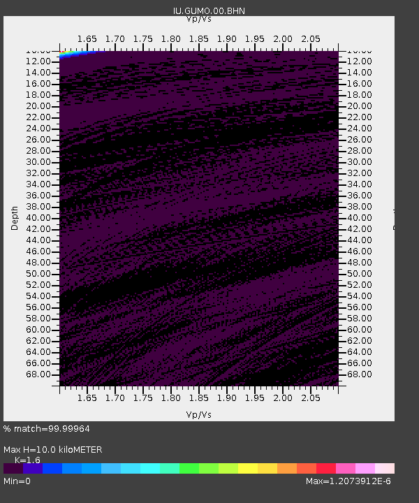
| Estimated Moho Depth: |
10.0 km |
| Estimated Crust Vp/Vs: |
1.60 |
| Assumed Crust Vp: |
4.802 km/s |
| Estimated Crust Vs: |
3.001 km/s |
| Estimated Crust Poisson's Ratio: |
0.18 |
|
| Radial Match: |
99.99964 % |
| Radial Bump: |
2 |
| Transverse Match: |
100.0 % |
| Transverse Bump: |
2 |
| SOD ConfigId: |
2665 |
| Insert Time: |
2010-03-03 14:39:39.872 +0000 |
| GWidth: |
2.5 |
| Max Bumps: |
400 |
| Tol: |
0.001 |
|
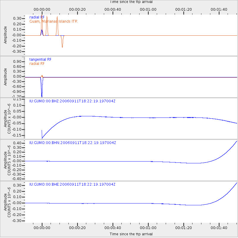
Signal To Noise
| Channel | StoN | STA | LTA |
| IU:GUMO:00:BHN:20060911T18:22:19.197004Z | 0.9105494 | 3.3734477E-8 | 3.7048487E-8 |
| IU:GUMO:00:BHE:20060911T18:22:19.197004Z | 0.9119724 | 2.6065697E-8 | 2.8581674E-8 |
| IU:GUMO:00:BHZ:20060911T18:22:19.197004Z | 0.9123921 | 4.9405436E-8 | 5.414935E-8 |
| Arrivals |
| Ps | 1.3 SECOND |
| PpPs | 5.3 SECOND |
| PsPs/PpSs | 6.6 SECOND |


