You are here: Home > Network List > TA - USArray Transportable Network (new EarthScope stations) Stations List
> Station 121A Cookes Peak, Deming, NM, USA > Earthquake Result Viewer
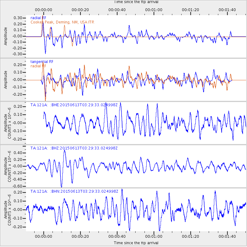
121A Cookes Peak, Deming, NM, USA - Earthquake Result Viewer
*The percent match for this event was below the threshold and hence no stack was calculated.
| Earthquake location: |
South Of Fiji Islands |
| Earthquake latitude/longitude: |
-24.6/-176.2 |
| Earthquake time(UTC): |
2015/06/13 (164) 03:17:24 GMT |
| Earthquake Depth: |
22 km |
| Earthquake Magnitude: |
5.5 MWW, 5.5 MWB, 5.6 MWC |
| Earthquake Catalog/Contributor: |
NEIC PDE/NEIC COMCAT |
|
| Network: |
TA USArray Transportable Network (new EarthScope stations) |
| Station: |
121A Cookes Peak, Deming, NM, USA |
| Lat/Lon: |
32.53 N/107.79 W |
| Elevation: |
1652 m |
|
| Distance: |
86.5 deg |
| Az: |
51.892 deg |
| Baz: |
237.995 deg |
| Ray Param: |
$rayparam |
*The percent match for this event was below the threshold and hence was not used in the summary stack. |
|
| Radial Match: |
65.55253 % |
| Radial Bump: |
400 |
| Transverse Match: |
70.42819 % |
| Transverse Bump: |
400 |
| SOD ConfigId: |
7422571 |
| Insert Time: |
2019-04-19 08:27:52.627 +0000 |
| GWidth: |
2.5 |
| Max Bumps: |
400 |
| Tol: |
0.001 |
|
Signal To Noise
| Channel | StoN | STA | LTA |
| TA:121A: :BHZ:20150613T03:29:33.024998Z | 3.6966708 | 1.4858816E-7 | 4.0195125E-8 |
| TA:121A: :BHN:20150613T03:29:33.024998Z | 0.4105613 | 2.1757302E-8 | 5.299404E-8 |
| TA:121A: :BHE:20150613T03:29:33.024998Z | 1.6764679 | 1.1378019E-7 | 6.786899E-8 |
| Arrivals |
| Ps | |
| PpPs | |
| PsPs/PpSs | |


