GUMO Guam, Marianas Islands - Earthquake Result Viewer
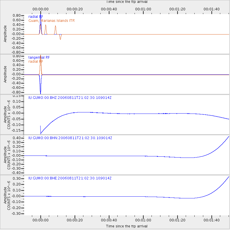
Earthquake location: Northern Sumatra, Indonesia
Earthquake latitude/longitude: 2.4/96.3
Earthquake time(UTC): 2006/08/11 (223) 20:54:14 GMT
Earthquake Depth: 22 km
Earthquake Magnitude: 5.8 MB, 6.2 MS, 6.2 MW, 6.1 MW
Earthquake Catalog/Contributor: WHDF/NEIC
Network: IU Global Seismograph Network (GSN - IRIS/USGS)
Station: GUMO Guam, Marianas Islands
Lat/Lon: 13.59 N/144.87 E
Elevation: 14 m
Distance: 49.2 deg
Az: 74.179 deg
Baz: 261.34 deg
Ray Param: 0.06881239
Estimated Moho Depth: 10.0 km
Estimated Crust Vp/Vs: 1.60
Assumed Crust Vp: 4.802 km/s
Estimated Crust Vs: 3.001 km/s
Estimated Crust Poisson's Ratio: 0.18
Radial Match: 99.999985 %
Radial Bump: 2
Transverse Match: 99.99999 %
Transverse Bump: 2
SOD ConfigId: 2665
Insert Time: 2010-03-03 14:39:45.028 +0000
GWidth: 2.5
Max Bumps: 400
Tol: 0.001

Signal To Noise

ChannelStoNSTALTA
IU:GUMO:00:BHN:20060811T21:02:30.109014Z0.8991723.351835E-83.7276905E-8
IU:GUMO:00:BHE:20060811T21:02:30.109014Z0.90613642.5541828E-82.8187621E-8
IU:GUMO:00:BHZ:20060811T21:02:30.109014Z0.916817254.966486E-85.417095E-8
Arrivals
Ps1.3 SECOND
PpPs5.2 SECOND
PsPs/PpSs6.5 SECOND