You are here: Home > Network List > IU - Global Seismograph Network (GSN - IRIS/USGS) Stations List
> Station GUMO Guam, Marianas Islands > Earthquake Result Viewer
GUMO Guam, Marianas Islands - Earthquake Result Viewer
| Earthquake location: |
South Of Java, Indonesia |
| Earthquake latitude/longitude: |
-9.3/108.4 |
| Earthquake time(UTC): |
2006/07/25 (206) 12:39:23 GMT |
| Earthquake Depth: |
10 km |
| Earthquake Magnitude: |
5.6 MB |
| Earthquake Catalog/Contributor: |
WHDF/NEIC |
|
| Network: |
IU Global Seismograph Network (GSN - IRIS/USGS) |
| Station: |
GUMO Guam, Marianas Islands |
| Lat/Lon: |
13.59 N/144.87 E |
| Elevation: |
14 m |
|
| Distance: |
42.7 deg |
| Az: |
58.4 deg |
| Baz: |
239.845 deg |
| Ray Param: |
0.07300844 |
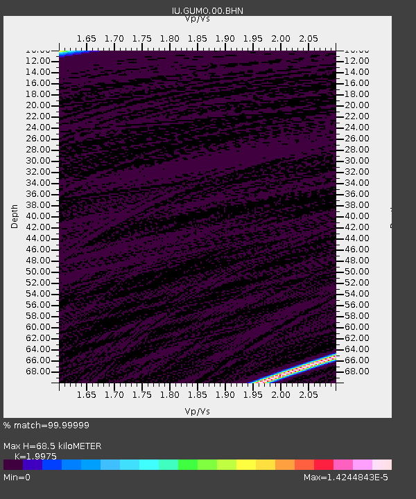
| Estimated Moho Depth: |
68.5 km |
| Estimated Crust Vp/Vs: |
2.00 |
| Assumed Crust Vp: |
4.802 km/s |
| Estimated Crust Vs: |
2.404 km/s |
| Estimated Crust Poisson's Ratio: |
0.33 |
|
| Radial Match: |
99.99999 % |
| Radial Bump: |
2 |
| Transverse Match: |
99.999985 % |
| Transverse Bump: |
2 |
| SOD ConfigId: |
2665 |
| Insert Time: |
2010-03-03 14:39:50.735 +0000 |
| GWidth: |
2.5 |
| Max Bumps: |
400 |
| Tol: |
0.001 |
|

Signal To Noise
| Channel | StoN | STA | LTA |
| IU:GUMO:00:BHN:20060725T12:46:50.111006Z | 0.92232186 | 3.4102648E-8 | 3.697478E-8 |
| IU:GUMO:00:BHE:20060725T12:46:50.111006Z | 0.910034 | 2.558741E-8 | 2.8116983E-8 |
| IU:GUMO:00:BHZ:20060725T12:46:50.111006Z | 0.91177773 | 4.9311485E-8 | 5.4082793E-8 |
| Arrivals |
| Ps | 15 SECOND |
| PpPs | 41 SECOND |
| PsPs/PpSs | 56 SECOND |


