You are here: Home > Network List > IU - Global Seismograph Network (GSN - IRIS/USGS) Stations List
> Station GUMO Guam, Marianas Islands > Earthquake Result Viewer
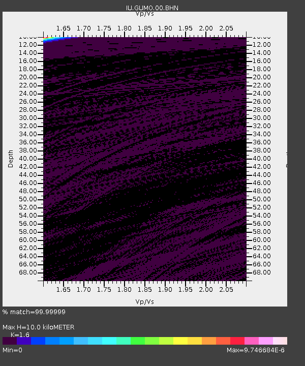
GUMO Guam, Marianas Islands - Earthquake Result Viewer
| Earthquake location: |
South Of Java, Indonesia |
| Earthquake latitude/longitude: |
-9.5/107.7 |
| Earthquake time(UTC): |
2006/07/17 (198) 15:42:02 GMT |
| Earthquake Depth: |
13 km |
| Earthquake Magnitude: |
5.5 MB |
| Earthquake Catalog/Contributor: |
WHDF/NEIC |
|
| Network: |
IU Global Seismograph Network (GSN - IRIS/USGS) |
| Station: |
GUMO Guam, Marianas Islands |
| Lat/Lon: |
13.59 N/144.87 E |
| Elevation: |
14 m |
|
| Distance: |
43.4 deg |
| Az: |
58.654 deg |
| Baz: |
240.037 deg |
| Ray Param: |
0.07254008 |
| Estimated Moho Depth: |
10.0 km |
| Estimated Crust Vp/Vs: |
1.60 |
| Assumed Crust Vp: |
4.802 km/s |
| Estimated Crust Vs: |
3.001 km/s |
| Estimated Crust Poisson's Ratio: |
0.18 |
|
| Radial Match: |
99.99999 % |
| Radial Bump: |
2 |
| Transverse Match: |
99.99998 % |
| Transverse Bump: |
2 |
| SOD ConfigId: |
2665 |
| Insert Time: |
2010-03-03 14:40:01.056 +0000 |
| GWidth: |
2.5 |
| Max Bumps: |
400 |
| Tol: |
0.001 |
|

Signal To Noise
| Channel | StoN | STA | LTA |
| IU:GUMO:00:BHN:20060717T15:49:34.347009Z | 0.9126135 | 3.3899397E-8 | 3.7145405E-8 |
| IU:GUMO:00:BHE:20060717T15:49:34.347009Z | 0.90950143 | 2.610847E-8 | 2.8706355E-8 |
| IU:GUMO:00:BHZ:20060717T15:49:34.347009Z | 0.90871155 | 4.937972E-8 | 5.434037E-8 |
| Arrivals |
| Ps | 1.3 SECOND |
| PpPs | 5.2 SECOND |
| PsPs/PpSs | 6.5 SECOND |


