You are here: Home > Network List > IU - Global Seismograph Network (GSN - IRIS/USGS) Stations List
> Station GUMO Guam, Marianas Islands > Earthquake Result Viewer
GUMO Guam, Marianas Islands - Earthquake Result Viewer
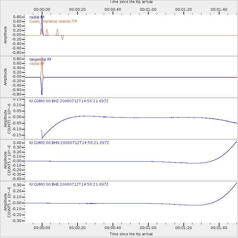
| Earthquake location: |
Mid-Indian Ridge |
| Earthquake latitude/longitude: |
-8.5/67.8 |
| Earthquake time(UTC): |
2006/07/12 (193) 14:44:45 GMT |
| Earthquake Depth: |
10 km |
| Earthquake Magnitude: |
5.1 MB, 5.1 MS, 5.7 MW, 5.6 MW |
| Earthquake Catalog/Contributor: |
WHDF/NEIC |
|
| Network: |
IU Global Seismograph Network (GSN - IRIS/USGS) |
| Station: |
GUMO Guam, Marianas Islands |
| Lat/Lon: |
13.59 N/144.87 E |
| Elevation: |
14 m |
|
| Distance: |
79.6 deg |
| Az: |
74.486 deg |
| Baz: |
258.545 deg |
| Ray Param: |
0.048869446 |
| Estimated Moho Depth: |
10.0 km |
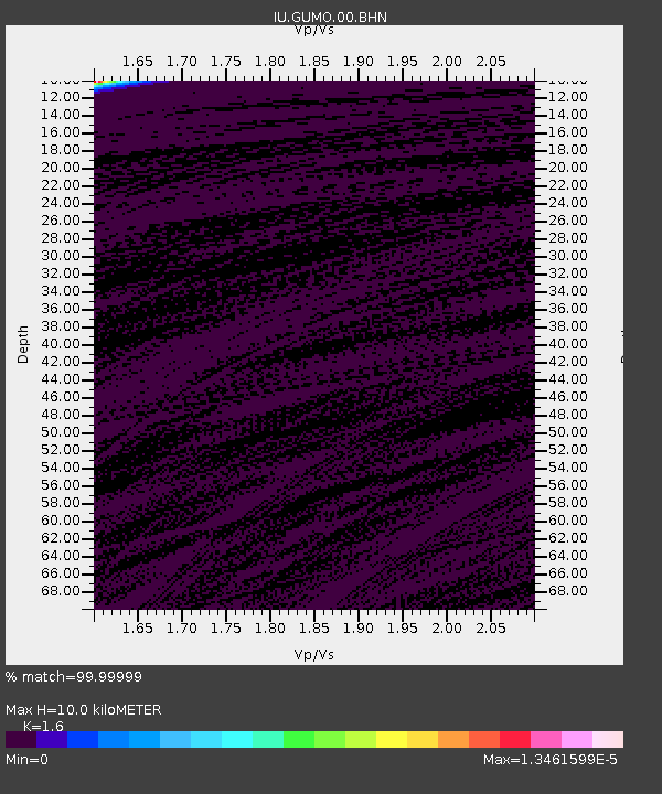
| Estimated Crust Vp/Vs: |
1.60 |
| Assumed Crust Vp: |
4.802 km/s |
| Estimated Crust Vs: |
3.001 km/s |
| Estimated Crust Poisson's Ratio: |
0.18 |
|
| Radial Match: |
99.99999 % |
| Radial Bump: |
2 |
| Transverse Match: |
99.99999 % |
| Transverse Bump: |
2 |
| SOD ConfigId: |
2665 |
| Insert Time: |
2010-03-03 14:40:10.663 +0000 |
| GWidth: |
2.5 |
| Max Bumps: |
400 |
| Tol: |
0.001 |
|
Signal To Noise
| Channel | StoN | STA | LTA |
| IU:GUMO:00:BHN:20060712T14:56:21.697Z | 0.9033342 | 3.3709753E-8 | 3.7317037E-8 |
| IU:GUMO:00:BHE:20060712T14:56:21.697Z | 0.91161466 | 2.6030218E-8 | 2.855397E-8 |
| IU:GUMO:00:BHZ:20060712T14:56:21.697Z | 0.9058348 | 4.9219345E-8 | 5.43359E-8 |
| Arrivals |
| Ps | 1.3 SECOND |
| PpPs | 5.3 SECOND |
| PsPs/PpSs | 6.6 SECOND |


