You are here: Home > Network List > IU - Global Seismograph Network (GSN - IRIS/USGS) Stations List
> Station GUMO Guam, Marianas Islands > Earthquake Result Viewer
GUMO Guam, Marianas Islands - Earthquake Result Viewer

| Earthquake location: |
Mid-Indian Ridge |
| Earthquake latitude/longitude: |
-36.8/78.5 |
| Earthquake time(UTC): |
2006/05/07 (127) 14:17:35 GMT |
| Earthquake Depth: |
10 km |
| Earthquake Magnitude: |
5.5 MB, 5.8 MS, 6.1 MW, 6.1 MW |
| Earthquake Catalog/Contributor: |
WHDF/NEIC |
|
| Network: |
IU Global Seismograph Network (GSN - IRIS/USGS) |
| Station: |
GUMO Guam, Marianas Islands |
| Lat/Lon: |
13.59 N/144.87 E |
| Elevation: |
14 m |
|
| Distance: |
80.0 deg |
| Az: |
64.733 deg |
| Baz: |
228.283 deg |
| Ray Param: |
0.04859674 |
| Estimated Moho Depth: |
10.0 km |
| Estimated Crust Vp/Vs: |
1.60 |
| Assumed Crust Vp: |
4.802 km/s |
| Estimated Crust Vs: |
3.001 km/s |
| Estimated Crust Poisson's Ratio: |
0.18 |
|
| Radial Match: |
100.0 % |
| Radial Bump: |
2 |
| Transverse Match: |
99.99991 % |
| Transverse Bump: |
2 |
| SOD ConfigId: |
2669 |
| Insert Time: |
2010-03-03 14:40:22.876 +0000 |
| GWidth: |
2.5 |
| Max Bumps: |
400 |
| Tol: |
0.001 |
|
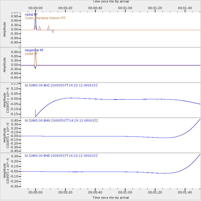
Signal To Noise
| Channel | StoN | STA | LTA |
| IU:GUMO:00:BHN:20060507T14:29:13.060015Z | 0.91362846 | 3.4042895E-8 | 3.7261202E-8 |
| IU:GUMO:00:BHE:20060507T14:29:13.060015Z | 0.9026192 | 2.5968664E-8 | 2.8770343E-8 |
| IU:GUMO:00:BHZ:20060507T14:29:13.060015Z | 0.90812147 | 4.9230533E-8 | 5.4211398E-8 |
| Arrivals |
| Ps | 1.3 SECOND |
| PpPs | 5.3 SECOND |
| PsPs/PpSs | 6.6 SECOND |


