You are here: Home > Network List > UW - Pacific Northwest Regional Seismic Network Stations List
> Station UMAT Pilot Rock, OR, USA > Earthquake Result Viewer
UMAT Pilot Rock, OR, USA - Earthquake Result Viewer
*The percent match for this event was below the threshold and hence no stack was calculated.
| Earthquake location: |
Near N Coast Of New Guinea, P.N.G. |
| Earthquake latitude/longitude: |
-3.2/143.8 |
| Earthquake time(UTC): |
2015/06/13 (164) 07:08:58 GMT |
| Earthquake Depth: |
10 km |
| Earthquake Magnitude: |
5.6 MB |
| Earthquake Catalog/Contributor: |
NEIC PDE/NEIC ALERT |
|
| Network: |
UW Pacific Northwest Regional Seismic Network |
| Station: |
UMAT Pilot Rock, OR, USA |
| Lat/Lon: |
45.29 N/118.96 W |
| Elevation: |
1318 m |
|
| Distance: |
97.4 deg |
| Az: |
44.923 deg |
| Baz: |
272.827 deg |
| Ray Param: |
$rayparam |
*The percent match for this event was below the threshold and hence was not used in the summary stack. |
|
| Radial Match: |
52.98929 % |
| Radial Bump: |
352 |
| Transverse Match: |
58.103325 % |
| Transverse Bump: |
346 |
| SOD ConfigId: |
7422571 |
| Insert Time: |
2019-04-19 08:34:16.501 +0000 |
| GWidth: |
2.5 |
| Max Bumps: |
400 |
| Tol: |
0.001 |
|
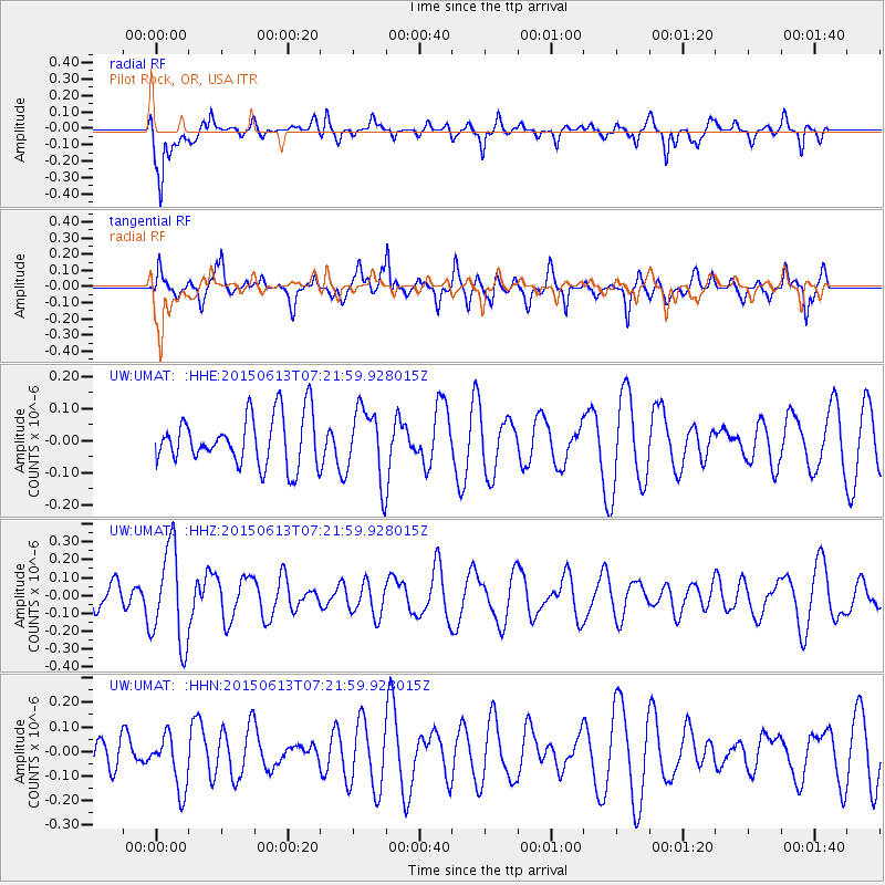
Signal To Noise
| Channel | StoN | STA | LTA |
| UW:UMAT: :HHZ:20150613T07:21:59.928015Z | 3.5733333 | 2.694805E-7 | 7.541432E-8 |
| UW:UMAT: :HHN:20150613T07:21:59.928015Z | 1.7243941 | 1.1166118E-7 | 6.475386E-8 |
| UW:UMAT: :HHE:20150613T07:21:59.928015Z | 1.519868 | 1.1876397E-7 | 7.814098E-8 |
| Arrivals |
| Ps | |
| PpPs | |
| PsPs/PpSs | |


