You are here: Home > Network List > IU - Global Seismograph Network (GSN - IRIS/USGS) Stations List
> Station GUMO Guam, Marianas Islands > Earthquake Result Viewer
GUMO Guam, Marianas Islands - Earthquake Result Viewer
| Earthquake location: |
Santa Cruz Islands |
| Earthquake latitude/longitude: |
-12.0/166.4 |
| Earthquake time(UTC): |
2000/08/03 (216) 01:09:38 GMT |
| Earthquake Depth: |
33 km |
| Earthquake Magnitude: |
5.7 MB, 6.5 MS, 6.7 MW, 6.6 MW |
| Earthquake Catalog/Contributor: |
WHDF/NEIC |
|
| Network: |
IU Global Seismograph Network (GSN - IRIS/USGS) |
| Station: |
GUMO Guam, Marianas Islands |
| Lat/Lon: |
13.59 N/144.87 E |
| Elevation: |
14 m |
|
| Distance: |
33.3 deg |
| Az: |
319.294 deg |
| Baz: |
138.993 deg |
| Ray Param: |
0.07823684 |
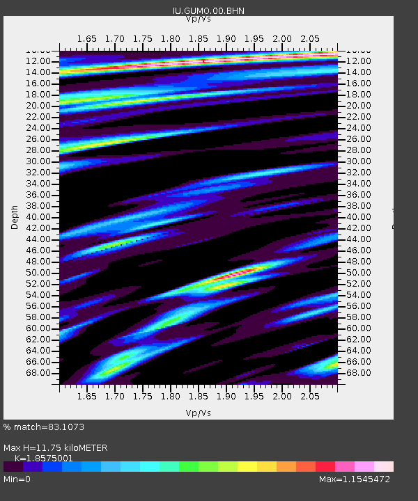
| Estimated Moho Depth: |
11.75 km |
| Estimated Crust Vp/Vs: |
1.86 |
| Assumed Crust Vp: |
4.802 km/s |
| Estimated Crust Vs: |
2.585 km/s |
| Estimated Crust Poisson's Ratio: |
0.30 |
|
| Radial Match: |
83.1073 % |
| Radial Bump: |
360 |
| Transverse Match: |
72.46899 % |
| Transverse Bump: |
400 |
| SOD ConfigId: |
3744 |
| Insert Time: |
2010-03-03 14:40:34.437 +0000 |
| GWidth: |
2.5 |
| Max Bumps: |
400 |
| Tol: |
0.001 |
|
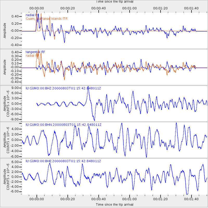
Signal To Noise
| Channel | StoN | STA | LTA |
| IU:GUMO:00:BHN:20000803T01:15:42.848011Z | 2.257279 | 2.2211148E-6 | 9.839789E-7 |
| IU:GUMO:00:BHE:20000803T01:15:42.848011Z | 1.830033 | 1.7110425E-6 | 9.349791E-7 |
| IU:GUMO:00:BHZ:20000803T01:15:42.848011Z | 6.1322374 | 4.234385E-6 | 6.9051225E-7 |
| Arrivals |
| Ps | 2.2 SECOND |
| PpPs | 6.7 SECOND |
| PsPs/PpSs | 8.9 SECOND |


