You are here: Home > Network List > US - United States National Seismic Network Stations List
> Station AGMN Agassiz National Wildlife Refuge, Minnesota, USA > Earthquake Result Viewer
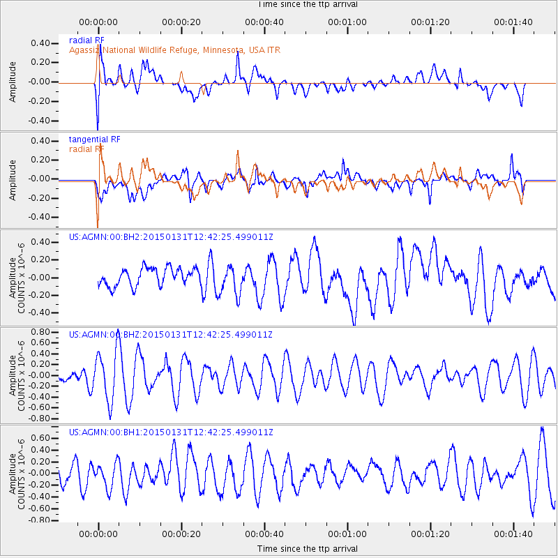
AGMN Agassiz National Wildlife Refuge, Minnesota, USA - Earthquake Result Viewer
*The percent match for this event was below the threshold and hence no stack was calculated.
| Earthquake location: |
Mariana Islands Region |
| Earthquake latitude/longitude: |
15.3/147.1 |
| Earthquake time(UTC): |
2015/01/31 (031) 12:29:31 GMT |
| Earthquake Depth: |
10 km |
| Earthquake Magnitude: |
5.7 MO |
| Earthquake Catalog/Contributor: |
NEIC PDE/NEIC ALERT |
|
| Network: |
US United States National Seismic Network |
| Station: |
AGMN Agassiz National Wildlife Refuge, Minnesota, USA |
| Lat/Lon: |
48.30 N/95.86 W |
| Elevation: |
351 m |
|
| Distance: |
95.6 deg |
| Az: |
36.705 deg |
| Baz: |
300.249 deg |
| Ray Param: |
$rayparam |
*The percent match for this event was below the threshold and hence was not used in the summary stack. |
|
| Radial Match: |
49.71135 % |
| Radial Bump: |
400 |
| Transverse Match: |
51.24324 % |
| Transverse Bump: |
400 |
| SOD ConfigId: |
837871 |
| Insert Time: |
2015-02-14 12:38:39.609 +0000 |
| GWidth: |
2.5 |
| Max Bumps: |
400 |
| Tol: |
0.001 |
|
Signal To Noise
| Channel | StoN | STA | LTA |
| US:AGMN:00:BHZ:20150131T12:42:25.499011Z | 5.3676386 | 4.7351887E-7 | 8.821735E-8 |
| US:AGMN:00:BH1:20150131T12:42:25.499011Z | 0.8966953 | 2.1754718E-7 | 2.4260993E-7 |
| US:AGMN:00:BH2:20150131T12:42:25.499011Z | 1.7236301 | 1.6827461E-7 | 9.762803E-8 |
| Arrivals |
| Ps | |
| PpPs | |
| PsPs/PpSs | |


