You are here: Home > Network List > IU - Global Seismograph Network (GSN - IRIS/USGS) Stations List
> Station GUMO Guam, Marianas Islands > Earthquake Result Viewer
GUMO Guam, Marianas Islands - Earthquake Result Viewer
*The percent match for this event was below the threshold and hence no stack was calculated.
| Earthquake location: |
Tonga Islands |
| Earthquake latitude/longitude: |
-18.4/-175.4 |
| Earthquake time(UTC): |
2008/10/22 (296) 12:55:57 GMT |
| Earthquake Depth: |
233 km |
| Earthquake Magnitude: |
5.9 MB, 6.4 MW, 6.3 MW |
| Earthquake Catalog/Contributor: |
WHDF/NEIC |
|
| Network: |
IU Global Seismograph Network (GSN - IRIS/USGS) |
| Station: |
GUMO Guam, Marianas Islands |
| Lat/Lon: |
13.59 N/144.87 E |
| Elevation: |
14 m |
|
| Distance: |
50.5 deg |
| Az: |
306.253 deg |
| Baz: |
128.057 deg |
| Ray Param: |
$rayparam |
*The percent match for this event was below the threshold and hence was not used in the summary stack. |
|
| Radial Match: |
76.7666 % |
| Radial Bump: |
400 |
| Transverse Match: |
65.81355 % |
| Transverse Bump: |
400 |
| SOD ConfigId: |
2556 |
| Insert Time: |
2010-03-03 14:41:19.908 +0000 |
| GWidth: |
2.5 |
| Max Bumps: |
400 |
| Tol: |
0.001 |
|
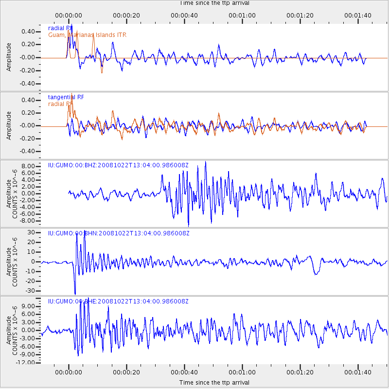
Signal To Noise
| Channel | StoN | STA | LTA |
| IU:GUMO:00:BHN:20081022T13:04:00.986008Z | 19.635569 | 1.2252731E-5 | 6.2400693E-7 |
| IU:GUMO:00:BHE:20081022T13:04:00.986008Z | 5.423597 | 4.6536647E-6 | 8.580403E-7 |
| IU:GUMO:00:BHZ:20081022T13:04:00.986008Z | 2.4764638 | 2.0495575E-6 | 8.2761454E-7 |
| Arrivals |
| Ps | |
| PpPs | |
| PsPs/PpSs | |


