You are here: Home > Network List > IU - Global Seismograph Network (GSN - IRIS/USGS) Stations List
> Station GUMO Guam, Marianas Islands > Earthquake Result Viewer
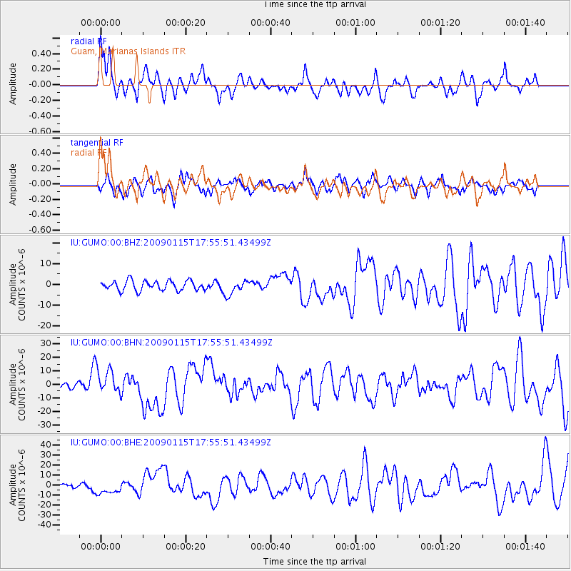
GUMO Guam, Marianas Islands - Earthquake Result Viewer
*The percent match for this event was below the threshold and hence no stack was calculated.
| Earthquake location: |
East Of Kuril Islands |
| Earthquake latitude/longitude: |
46.9/155.2 |
| Earthquake time(UTC): |
2009/01/15 (015) 17:49:39 GMT |
| Earthquake Depth: |
36 km |
| Earthquake Magnitude: |
6.9 MB, 7.5 MS, 7.4 MW, 7.4 MW |
| Earthquake Catalog/Contributor: |
WHDF/NEIC |
|
| Network: |
IU Global Seismograph Network (GSN - IRIS/USGS) |
| Station: |
GUMO Guam, Marianas Islands |
| Lat/Lon: |
13.59 N/144.87 E |
| Elevation: |
14 m |
|
| Distance: |
34.3 deg |
| Az: |
197.962 deg |
| Baz: |
12.571 deg |
| Ray Param: |
$rayparam |
*The percent match for this event was below the threshold and hence was not used in the summary stack. |
|
| Radial Match: |
67.02802 % |
| Radial Bump: |
400 |
| Transverse Match: |
63.132427 % |
| Transverse Bump: |
400 |
| SOD ConfigId: |
2834 |
| Insert Time: |
2010-03-03 14:41:25.003 +0000 |
| GWidth: |
2.5 |
| Max Bumps: |
400 |
| Tol: |
0.001 |
|
Signal To Noise
| Channel | StoN | STA | LTA |
| IU:GUMO:00:BHN:20090115T17:55:51.43499Z | 5.028843 | 8.666989E-6 | 1.7234559E-6 |
| IU:GUMO:00:BHE:20090115T17:55:51.43499Z | 3.0508137 | 6.6013117E-6 | 2.1637873E-6 |
| IU:GUMO:00:BHZ:20090115T17:55:51.43499Z | 1.5391846 | 3.5792311E-6 | 2.3254074E-6 |
| Arrivals |
| Ps | |
| PpPs | |
| PsPs/PpSs | |


