You are here: Home > Network List > IU - Global Seismograph Network (GSN - IRIS/USGS) Stations List
> Station RSSD Black Hills, South Dakota, USA > Earthquake Result Viewer
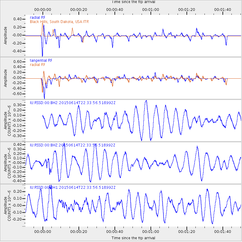
RSSD Black Hills, South Dakota, USA - Earthquake Result Viewer
*The percent match for this event was below the threshold and hence no stack was calculated.
| Earthquake location: |
Bonin Islands, Japan Region |
| Earthquake latitude/longitude: |
27.4/140.1 |
| Earthquake time(UTC): |
2015/06/14 (165) 22:22:20 GMT |
| Earthquake Depth: |
385 km |
| Earthquake Magnitude: |
4.9 mb |
| Earthquake Catalog/Contributor: |
ISC/ISC |
|
| Network: |
IU Global Seismograph Network (GSN - IRIS/USGS) |
| Station: |
RSSD Black Hills, South Dakota, USA |
| Lat/Lon: |
44.12 N/104.04 W |
| Elevation: |
2090 m |
|
| Distance: |
87.8 deg |
| Az: |
40.431 deg |
| Baz: |
306.792 deg |
| Ray Param: |
$rayparam |
*The percent match for this event was below the threshold and hence was not used in the summary stack. |
|
| Radial Match: |
65.18378 % |
| Radial Bump: |
400 |
| Transverse Match: |
79.64595 % |
| Transverse Bump: |
374 |
| SOD ConfigId: |
7422571 |
| Insert Time: |
2019-04-19 08:42:27.691 +0000 |
| GWidth: |
2.5 |
| Max Bumps: |
400 |
| Tol: |
0.001 |
|
Signal To Noise
| Channel | StoN | STA | LTA |
| IU:RSSD:00:BHZ:20150614T22:33:56.518992Z | 0.6409287 | 9.5565014E-8 | 1.4910397E-7 |
| IU:RSSD:00:BH1:20150614T22:33:56.518992Z | 1.9743799 | 1.8765087E-7 | 9.504294E-8 |
| IU:RSSD:00:BH2:20150614T22:33:56.518992Z | 0.65389675 | 8.153598E-8 | 1.2469243E-7 |
| Arrivals |
| Ps | |
| PpPs | |
| PsPs/PpSs | |


