You are here: Home > Network List > IU - Global Seismograph Network (GSN - IRIS/USGS) Stations List
> Station GUMO Guam, Mariana Islands > Earthquake Result Viewer
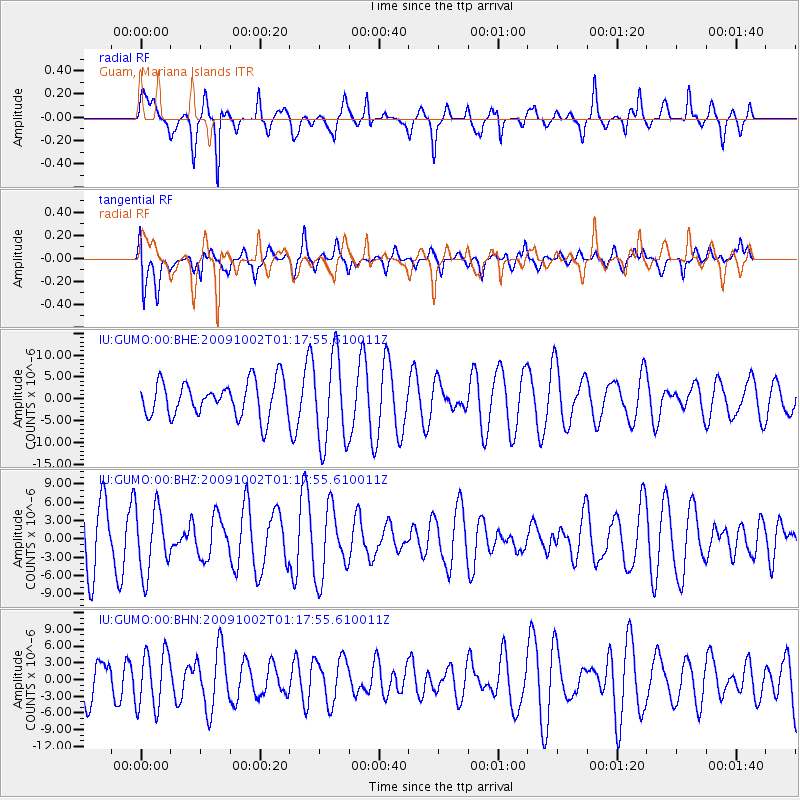
GUMO Guam, Mariana Islands - Earthquake Result Viewer
*The percent match for this event was below the threshold and hence no stack was calculated.
| Earthquake location: |
Tonga Islands |
| Earthquake latitude/longitude: |
-16.2/-173.5 |
| Earthquake time(UTC): |
2009/10/02 (275) 01:09:26 GMT |
| Earthquake Depth: |
10 km |
| Earthquake Magnitude: |
5.5 MB |
| Earthquake Catalog/Contributor: |
WHDF/NEIC |
|
| Network: |
IU Global Seismograph Network (GSN - IRIS/USGS) |
| Station: |
GUMO Guam, Mariana Islands |
| Lat/Lon: |
13.59 N/144.87 E |
| Elevation: |
170 m |
|
| Distance: |
50.7 deg |
| Az: |
303.402 deg |
| Baz: |
124.441 deg |
| Ray Param: |
$rayparam |
*The percent match for this event was below the threshold and hence was not used in the summary stack. |
|
| Radial Match: |
74.35426 % |
| Radial Bump: |
359 |
| Transverse Match: |
43.499496 % |
| Transverse Bump: |
400 |
| SOD ConfigId: |
2622 |
| Insert Time: |
2010-03-03 14:41:47.281 +0000 |
| GWidth: |
2.5 |
| Max Bumps: |
400 |
| Tol: |
0.001 |
|
Signal To Noise
| Channel | StoN | STA | LTA |
| IU:GUMO:00:BHZ:20091002T01:17:55.610011Z | 1.3161057 | 5.342491E-6 | 4.0593177E-6 |
| IU:GUMO:00:BHN:20091002T01:17:55.610011Z | 1.4102918 | 5.0563026E-6 | 3.5852884E-6 |
| IU:GUMO:00:BHE:20091002T01:17:55.610011Z | 2.5408568 | 1.0170928E-5 | 4.002952E-6 |
| Arrivals |
| Ps | |
| PpPs | |
| PsPs/PpSs | |


