You are here: Home > Network List > IU - Global Seismograph Network (GSN - IRIS/USGS) Stations List
> Station GUMO Guam, Marianas Islands > Earthquake Result Viewer
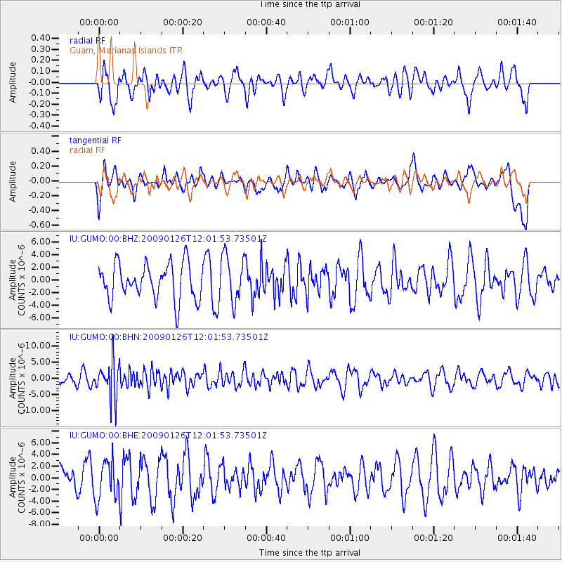
GUMO Guam, Marianas Islands - Earthquake Result Viewer
*The percent match for this event was below the threshold and hence no stack was calculated.
| Earthquake location: |
Fiji Islands Region |
| Earthquake latitude/longitude: |
-17.8/-178.6 |
| Earthquake time(UTC): |
2009/01/26 (026) 11:54:39 GMT |
| Earthquake Depth: |
580 km |
| Earthquake Magnitude: |
5.5 MB, 5.8 MW, 5.8 MW |
| Earthquake Catalog/Contributor: |
WHDF/NEIC |
|
| Network: |
IU Global Seismograph Network (GSN - IRIS/USGS) |
| Station: |
GUMO Guam, Marianas Islands |
| Lat/Lon: |
13.59 N/144.87 E |
| Elevation: |
14 m |
|
| Distance: |
47.7 deg |
| Az: |
308.451 deg |
| Baz: |
129.885 deg |
| Ray Param: |
$rayparam |
*The percent match for this event was below the threshold and hence was not used in the summary stack. |
|
| Radial Match: |
55.25258 % |
| Radial Bump: |
400 |
| Transverse Match: |
45.983288 % |
| Transverse Bump: |
400 |
| SOD ConfigId: |
2658 |
| Insert Time: |
2010-03-03 14:42:28.919 +0000 |
| GWidth: |
2.5 |
| Max Bumps: |
400 |
| Tol: |
0.001 |
|
Signal To Noise
| Channel | StoN | STA | LTA |
| IU:GUMO:00:BHN:20090126T12:01:53.73501Z | 3.6889126 | 5.6717204E-6 | 1.5375047E-6 |
| IU:GUMO:00:BHE:20090126T12:01:53.73501Z | 1.1131841 | 3.3314723E-6 | 2.9927414E-6 |
| IU:GUMO:00:BHZ:20090126T12:01:53.73501Z | 1.3148652 | 3.7002173E-6 | 2.814142E-6 |
| Arrivals |
| Ps | |
| PpPs | |
| PsPs/PpSs | |


