You are here: Home > Network List > IU - Global Seismograph Network (GSN - IRIS/USGS) Stations List
> Station GUMO Guam, Marianas Islands > Earthquake Result Viewer
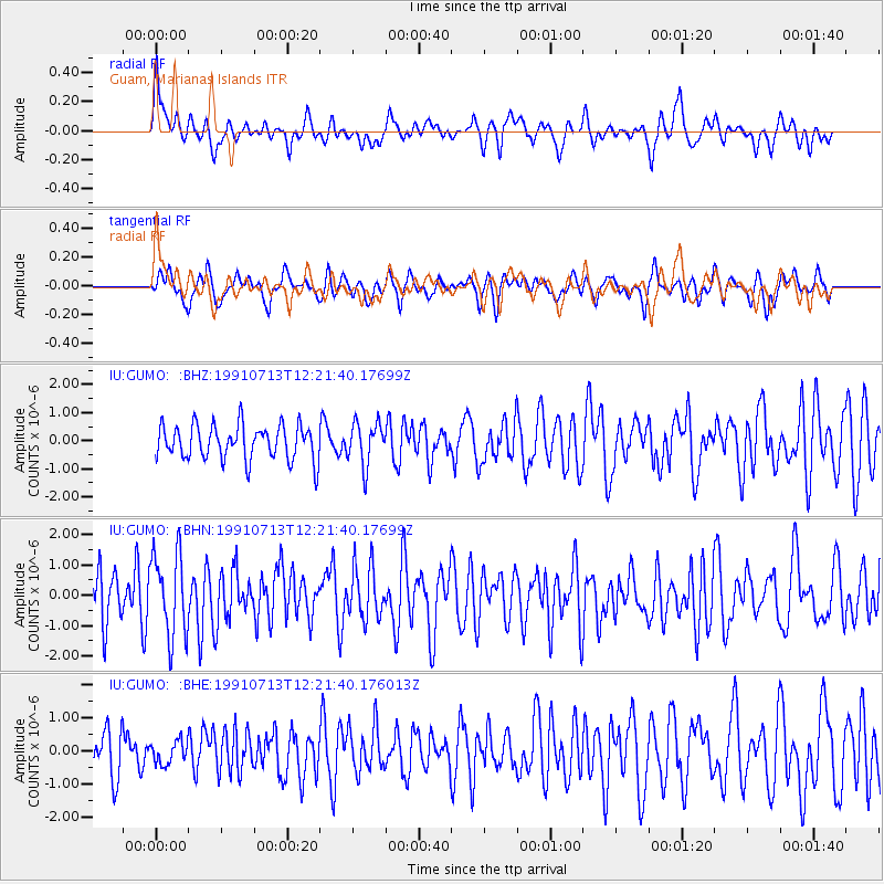
GUMO Guam, Marianas Islands - Earthquake Result Viewer
*The percent match for this event was below the threshold and hence no stack was calculated.
| Earthquake location: |
Kuril Islands |
| Earthquake latitude/longitude: |
48.7/154.9 |
| Earthquake time(UTC): |
1991/07/13 (194) 12:15:13 GMT |
| Earthquake Depth: |
40 km |
| Earthquake Magnitude: |
5.7 MB, 5.9 MS, 5.7 UNKNOWN |
| Earthquake Catalog/Contributor: |
WHDF/NEIC |
|
| Network: |
IU Global Seismograph Network (GSN - IRIS/USGS) |
| Station: |
GUMO Guam, Marianas Islands |
| Lat/Lon: |
13.59 N/144.87 E |
| Elevation: |
14 m |
|
| Distance: |
36.0 deg |
| Az: |
196.821 deg |
| Baz: |
11.364 deg |
| Ray Param: |
$rayparam |
*The percent match for this event was below the threshold and hence was not used in the summary stack. |
|
| Radial Match: |
51.61982 % |
| Radial Bump: |
400 |
| Transverse Match: |
53.81943 % |
| Transverse Bump: |
390 |
| SOD ConfigId: |
4480 |
| Insert Time: |
2010-03-03 14:42:36.391 +0000 |
| GWidth: |
2.5 |
| Max Bumps: |
400 |
| Tol: |
0.001 |
|
Signal To Noise
| Channel | StoN | STA | LTA |
| IU:GUMO: :BHN:19910713T12:21:40.17699Z | 1.957362 | 1.387255E-6 | 7.0873705E-7 |
| IU:GUMO: :BHE:19910713T12:21:40.176013Z | 0.445648 | 3.3534687E-7 | 7.524927E-7 |
| IU:GUMO: :BHZ:19910713T12:21:40.17699Z | 1.2306931 | 7.606593E-7 | 6.180739E-7 |
| Arrivals |
| Ps | |
| PpPs | |
| PsPs/PpSs | |


