You are here: Home > Network List > IU - Global Seismograph Network (GSN - IRIS/USGS) Stations List
> Station GUMO Guam, Marianas Islands > Earthquake Result Viewer
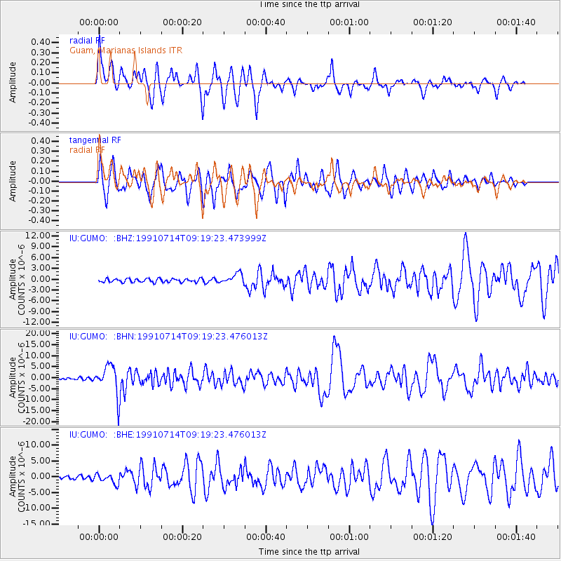
GUMO Guam, Marianas Islands - Earthquake Result Viewer
*The percent match for this event was below the threshold and hence no stack was calculated.
| Earthquake location: |
Afghanistan-Tajikistan Bord Reg. |
| Earthquake latitude/longitude: |
36.4/71.1 |
| Earthquake time(UTC): |
1991/07/14 (195) 09:09:13 GMT |
| Earthquake Depth: |
223 km |
| Earthquake Magnitude: |
6.4 MB |
| Earthquake Catalog/Contributor: |
WHDF/NEIC |
|
| Network: |
IU Global Seismograph Network (GSN - IRIS/USGS) |
| Station: |
GUMO Guam, Marianas Islands |
| Lat/Lon: |
13.59 N/144.87 E |
| Elevation: |
14 m |
|
| Distance: |
69.0 deg |
| Az: |
88.32 deg |
| Baz: |
303.963 deg |
| Ray Param: |
$rayparam |
*The percent match for this event was below the threshold and hence was not used in the summary stack. |
|
| Radial Match: |
79.66253 % |
| Radial Bump: |
400 |
| Transverse Match: |
79.50965 % |
| Transverse Bump: |
400 |
| SOD ConfigId: |
4480 |
| Insert Time: |
2010-03-03 14:42:37.489 +0000 |
| GWidth: |
2.5 |
| Max Bumps: |
400 |
| Tol: |
0.001 |
|
Signal To Noise
| Channel | StoN | STA | LTA |
| IU:GUMO: :BHN:19910714T09:19:23.476013Z | 16.306147 | 6.890426E-6 | 4.2256616E-7 |
| IU:GUMO: :BHE:19910714T09:19:23.476013Z | 3.4070992 | 1.578848E-6 | 4.6339946E-7 |
| IU:GUMO: :BHZ:19910714T09:19:23.473999Z | 2.9532254 | 1.4492164E-6 | 4.907232E-7 |
| Arrivals |
| Ps | |
| PpPs | |
| PsPs/PpSs | |


