You are here: Home > Network List > IU - Global Seismograph Network (GSN - IRIS/USGS) Stations List
> Station GUMO Guam, Marianas Islands > Earthquake Result Viewer
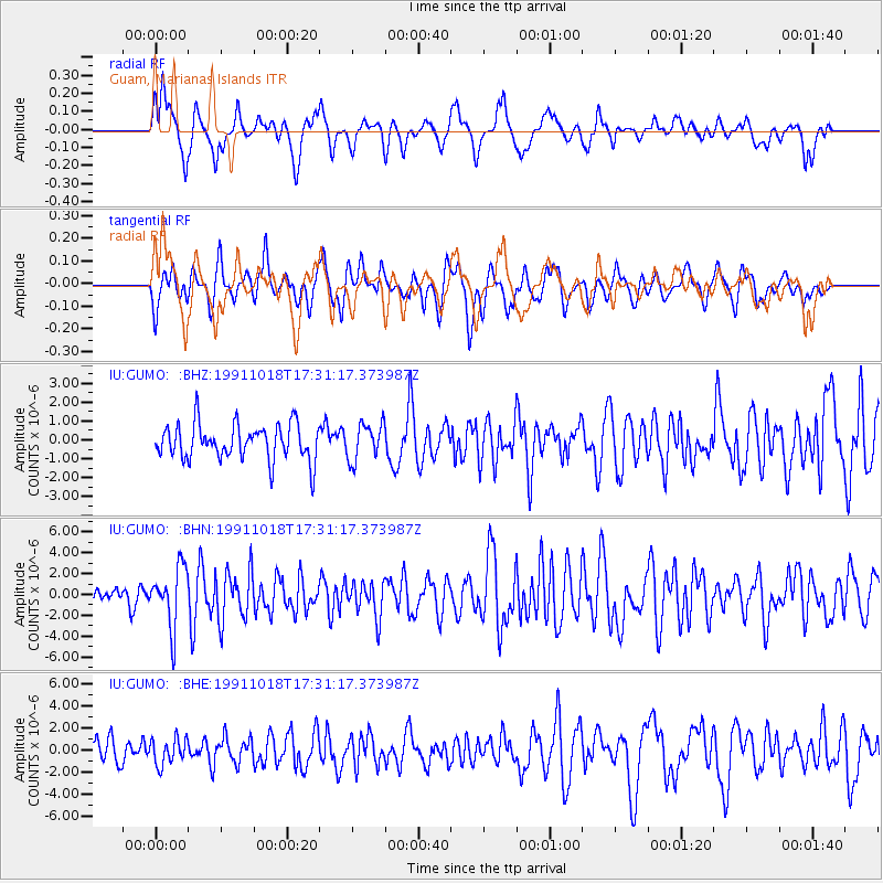
GUMO Guam, Marianas Islands - Earthquake Result Viewer
*The percent match for this event was below the threshold and hence no stack was calculated.
| Earthquake location: |
South Of Fiji Islands |
| Earthquake latitude/longitude: |
-24.2/-177.6 |
| Earthquake time(UTC): |
1991/10/18 (291) 17:22:55 GMT |
| Earthquake Depth: |
194 km |
| Earthquake Magnitude: |
5.8 MB |
| Earthquake Catalog/Contributor: |
WHDF/NEIC |
|
| Network: |
IU Global Seismograph Network (GSN - IRIS/USGS) |
| Station: |
GUMO Guam, Marianas Islands |
| Lat/Lon: |
13.59 N/144.87 E |
| Elevation: |
14 m |
|
| Distance: |
52.5 deg |
| Az: |
311.689 deg |
| Baz: |
135.47 deg |
| Ray Param: |
$rayparam |
*The percent match for this event was below the threshold and hence was not used in the summary stack. |
|
| Radial Match: |
65.68816 % |
| Radial Bump: |
376 |
| Transverse Match: |
60.951344 % |
| Transverse Bump: |
400 |
| SOD ConfigId: |
4480 |
| Insert Time: |
2010-03-03 14:42:39.191 +0000 |
| GWidth: |
2.5 |
| Max Bumps: |
400 |
| Tol: |
0.001 |
|
Signal To Noise
| Channel | StoN | STA | LTA |
| IU:GUMO: :BHN:19911018T17:31:17.373987Z | 3.7886918 | 2.840882E-6 | 7.498319E-7 |
| IU:GUMO: :BHE:19911018T17:31:17.373987Z | 1.0101861 | 1.1737976E-6 | 1.1619619E-6 |
| IU:GUMO: :BHZ:19911018T17:31:17.373987Z | 1.0438356 | 9.815567E-7 | 9.4033646E-7 |
| Arrivals |
| Ps | |
| PpPs | |
| PsPs/PpSs | |


