You are here: Home > Network List > CN - Canadian National Seismograph Network Stations List
> Station INK INUVIK, NT > Earthquake Result Viewer
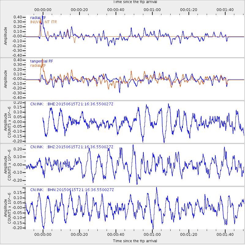
INK INUVIK, NT - Earthquake Result Viewer
*The percent match for this event was below the threshold and hence no stack was calculated.
| Earthquake location: |
Talaud Islands, Indonesia |
| Earthquake latitude/longitude: |
4.2/125.8 |
| Earthquake time(UTC): |
2015/06/15 (166) 21:04:24 GMT |
| Earthquake Depth: |
136 km |
| Earthquake Magnitude: |
5.7 MWW, 5.7 MWB, 5.8 MWC |
| Earthquake Catalog/Contributor: |
NEIC PDE/NEIC COMCAT |
|
| Network: |
CN Canadian National Seismograph Network |
| Station: |
INK INUVIK, NT |
| Lat/Lon: |
68.31 N/133.53 W |
| Elevation: |
44 m |
|
| Distance: |
90.1 deg |
| Az: |
21.433 deg |
| Baz: |
281.399 deg |
| Ray Param: |
$rayparam |
*The percent match for this event was below the threshold and hence was not used in the summary stack. |
|
| Radial Match: |
64.12344 % |
| Radial Bump: |
400 |
| Transverse Match: |
54.125538 % |
| Transverse Bump: |
400 |
| SOD ConfigId: |
7422571 |
| Insert Time: |
2019-04-19 08:53:51.948 +0000 |
| GWidth: |
2.5 |
| Max Bumps: |
400 |
| Tol: |
0.001 |
|
Signal To Noise
| Channel | StoN | STA | LTA |
| CN:INK: :BHZ:20150615T21:16:36.550027Z | 0.8228578 | 6.7840396E-8 | 8.244486E-8 |
| CN:INK: :BHN:20150615T21:16:36.550027Z | 2.5321422 | 1.10726916E-7 | 4.3728555E-8 |
| CN:INK: :BHE:20150615T21:16:36.550027Z | 0.55575806 | 3.8106577E-8 | 6.856685E-8 |
| Arrivals |
| Ps | |
| PpPs | |
| PsPs/PpSs | |


