You are here: Home > Network List > CI - Caltech Regional Seismic Network Stations List
> Station MPM Manuel Prospect Mine, California, USA > Earthquake Result Viewer
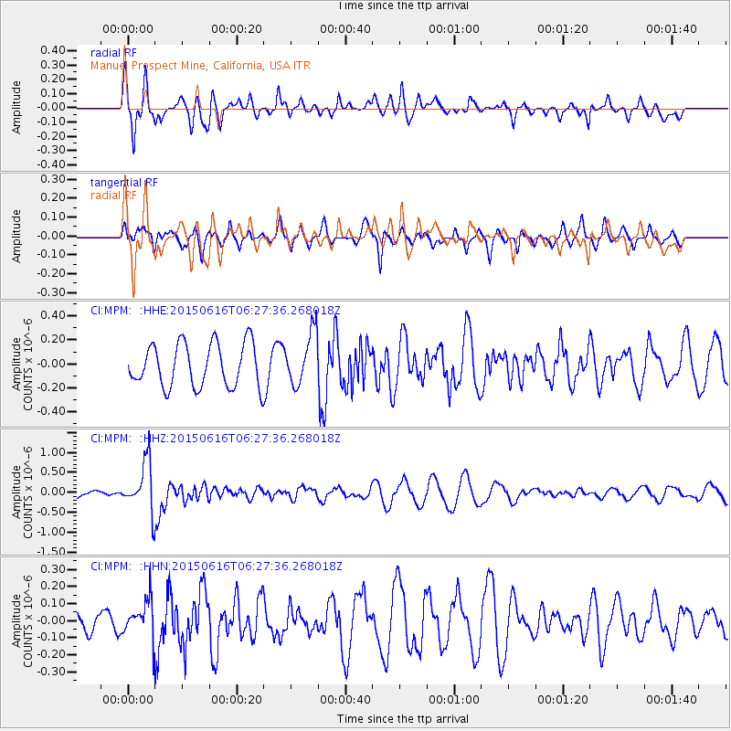
MPM Manuel Prospect Mine, California, USA - Earthquake Result Viewer
*The percent match for this event was below the threshold and hence no stack was calculated.
| Earthquake location: |
Fiji Islands Region |
| Earthquake latitude/longitude: |
-20.4/-178.9 |
| Earthquake time(UTC): |
2015/06/16 (167) 06:16:59 GMT |
| Earthquake Depth: |
646 km |
| Earthquake Magnitude: |
5.9 MO |
| Earthquake Catalog/Contributor: |
NEIC PDE/NEIC ALERT |
|
| Network: |
CI Caltech Regional Seismic Network |
| Station: |
MPM Manuel Prospect Mine, California, USA |
| Lat/Lon: |
36.06 N/117.49 W |
| Elevation: |
185 m |
|
| Distance: |
80.8 deg |
| Az: |
46.137 deg |
| Baz: |
236.581 deg |
| Ray Param: |
$rayparam |
*The percent match for this event was below the threshold and hence was not used in the summary stack. |
|
| Radial Match: |
72.52749 % |
| Radial Bump: |
350 |
| Transverse Match: |
59.56062 % |
| Transverse Bump: |
400 |
| SOD ConfigId: |
7422571 |
| Insert Time: |
2019-04-19 08:59:33.807 +0000 |
| GWidth: |
2.5 |
| Max Bumps: |
400 |
| Tol: |
0.001 |
|
Signal To Noise
| Channel | StoN | STA | LTA |
| CI:MPM: :HHZ:20150616T06:27:36.268018Z | 5.495307 | 6.416107E-7 | 1.1675612E-7 |
| CI:MPM: :HHN:20150616T06:27:36.268018Z | 1.915512 | 1.1470972E-7 | 5.988463E-8 |
| CI:MPM: :HHE:20150616T06:27:36.268018Z | 1.3509377 | 2.5042056E-7 | 1.8536797E-7 |
| Arrivals |
| Ps | |
| PpPs | |
| PsPs/PpSs | |


