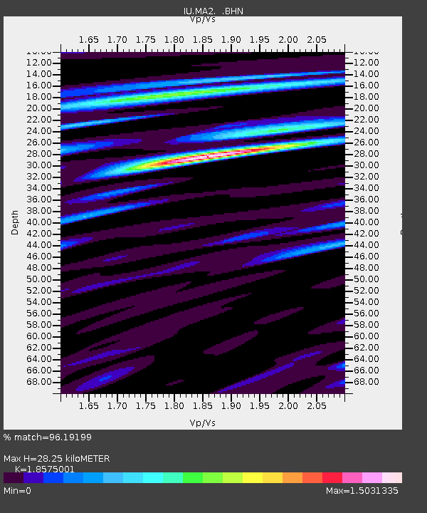
MA2 Magadan, Russia - Earthquake Result Viewer
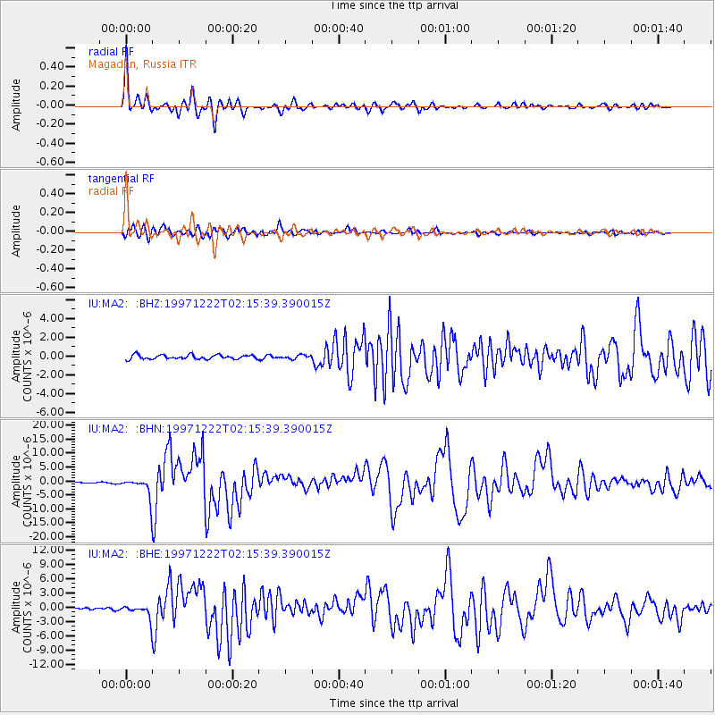
Earthquake location: Eastern New Guinea Reg., P.N.G.
Earthquake latitude/longitude: -5.5/147.9
Earthquake time(UTC): 1997/12/22 (356) 02:05:50 GMT
Earthquake Depth: 179 km
Earthquake Magnitude: 6.3 MB, 6.7 MS, 7.1 UNKNOWN, 7.0 ME
Earthquake Catalog/Contributor: WHDF/NEIC
Network: IU Global Seismograph Network (GSN - IRIS/USGS)
Station: MA2 Magadan, Russia
Lat/Lon: 59.58 N/150.77 E
Elevation: 339 m
Distance: 64.9 deg
Az: 1.631 deg
Baz: 183.191 deg
Ray Param: 0.05809278
Estimated Moho Depth: 28.25 km
Estimated Crust Vp/Vs: 1.86
Assumed Crust Vp: 6.134 km/s
Estimated Crust Vs: 3.302 km/s
Estimated Crust Poisson's Ratio: 0.30
Radial Match: 96.19199 %
Radial Bump: 400
Transverse Match: 91.49668 %
Transverse Bump: 400
SOD ConfigId: 4480
Insert Time: 2010-03-03 14:45:13.655 +0000
GWidth: 2.5
Max Bumps: 400
Tol: 0.001

Signal To Noise

ChannelStoNSTALTA
IU:MA2: :BHN:19971222T02:15:39.390015Z20.0816653.9352394E-61.959618E-7
IU:MA2: :BHE:19971222T02:15:39.390015Z8.2303971.5128321E-61.8381034E-7
IU:MA2: :BHZ:19971222T02:15:39.390015Z0.931187452.0526375E-72.2043224E-7
Arrivals
Ps4.1 SECOND
PpPs13 SECOND
PsPs/PpSs17 SECOND