You are here: Home > Network List > G - GEOSCOPE Stations List
> Station MPG Montagne des Peres, French Guyana > Earthquake Result Viewer
MPG Montagne des Peres, French Guyana - Earthquake Result Viewer
| Earthquake location: |
Mendoza Province, Argentina |
| Earthquake latitude/longitude: |
-32.7/-67.1 |
| Earthquake time(UTC): |
2015/02/02 (033) 10:49:48 GMT |
| Earthquake Depth: |
172 km |
| Earthquake Magnitude: |
6.3 MO |
| Earthquake Catalog/Contributor: |
NEIC PDE/NEIC ALERT |
|
| Network: |
G GEOSCOPE |
| Station: |
MPG Montagne des Peres, French Guyana |
| Lat/Lon: |
5.11 N/52.64 W |
| Elevation: |
147 m |
|
| Distance: |
40.0 deg |
| Az: |
22.679 deg |
| Baz: |
199.046 deg |
| Ray Param: |
0.0739974 |
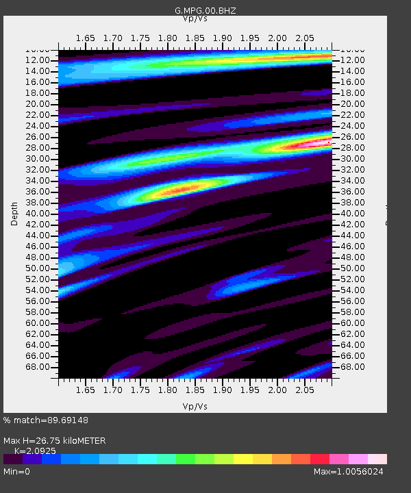
| Estimated Moho Depth: |
26.75 km |
| Estimated Crust Vp/Vs: |
2.09 |
| Assumed Crust Vp: |
6.472 km/s |
| Estimated Crust Vs: |
3.093 km/s |
| Estimated Crust Poisson's Ratio: |
0.35 |
|
| Radial Match: |
89.69148 % |
| Radial Bump: |
330 |
| Transverse Match: |
56.776836 % |
| Transverse Bump: |
400 |
| SOD ConfigId: |
837871 |
| Insert Time: |
2015-02-16 11:12:08.014 +0000 |
| GWidth: |
2.5 |
| Max Bumps: |
400 |
| Tol: |
0.001 |
|

Signal To Noise
| Channel | StoN | STA | LTA |
| G:MPG:00:BHZ:20150202T10:56:36.448993Z | 13.049556 | 3.316963E-6 | 2.5418208E-7 |
| G:MPG:00:BHN:20150202T10:56:36.448993Z | 8.047101 | 1.9509084E-6 | 2.4243616E-7 |
| G:MPG:00:BHE:20150202T10:56:36.448993Z | 5.2607827 | 1.1225875E-6 | 2.1338792E-7 |
| Arrivals |
| Ps | 4.8 SECOND |
| PpPs | 12 SECOND |
| PsPs/PpSs | 17 SECOND |


