You are here: Home > Network List > G - GEOSCOPE Stations List
> Station UNM Unam,Mexico > Earthquake Result Viewer
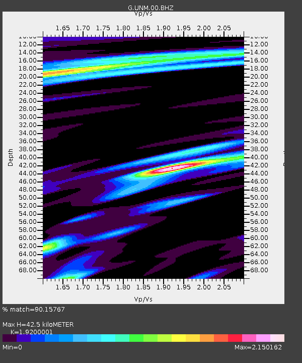
UNM Unam,Mexico - Earthquake Result Viewer
| Earthquake location: |
Mendoza Province, Argentina |
| Earthquake latitude/longitude: |
-32.7/-67.1 |
| Earthquake time(UTC): |
2015/02/02 (033) 10:49:48 GMT |
| Earthquake Depth: |
172 km |
| Earthquake Magnitude: |
6.3 MO |
| Earthquake Catalog/Contributor: |
NEIC PDE/NEIC ALERT |
|
| Network: |
G GEOSCOPE |
| Station: |
UNM Unam,Mexico |
| Lat/Lon: |
19.33 N/99.18 W |
| Elevation: |
2280 m |
|
| Distance: |
60.2 deg |
| Az: |
324.643 deg |
| Baz: |
148.897 deg |
| Ray Param: |
0.06115992 |
| Estimated Moho Depth: |
42.5 km |
| Estimated Crust Vp/Vs: |
1.92 |
| Assumed Crust Vp: |
6.597 km/s |
| Estimated Crust Vs: |
3.436 km/s |
| Estimated Crust Poisson's Ratio: |
0.31 |
|
| Radial Match: |
90.15767 % |
| Radial Bump: |
400 |
| Transverse Match: |
84.108406 % |
| Transverse Bump: |
400 |
| SOD ConfigId: |
837871 |
| Insert Time: |
2015-02-16 11:12:12.694 +0000 |
| GWidth: |
2.5 |
| Max Bumps: |
400 |
| Tol: |
0.001 |
|

Signal To Noise
| Channel | StoN | STA | LTA |
| G:UNM:00:BHZ:20150202T10:59:07.600024Z | 35.921677 | 7.813347E-6 | 2.1751065E-7 |
| G:UNM:00:BHN:20150202T10:59:07.600024Z | 4.8140717 | 1.6311118E-6 | 3.3882168E-7 |
| G:UNM:00:BHE:20150202T10:59:07.600024Z | 2.372627 | 8.763718E-7 | 3.693677E-7 |
| Arrivals |
| Ps | 6.2 SECOND |
| PpPs | 18 SECOND |
| PsPs/PpSs | 24 SECOND |


