You are here: Home > Network List > AV - Alaska Volcano Observatory Stations List
> Station SPCR Ckakachatna River, Mount Spurr, Alaska > Earthquake Result Viewer
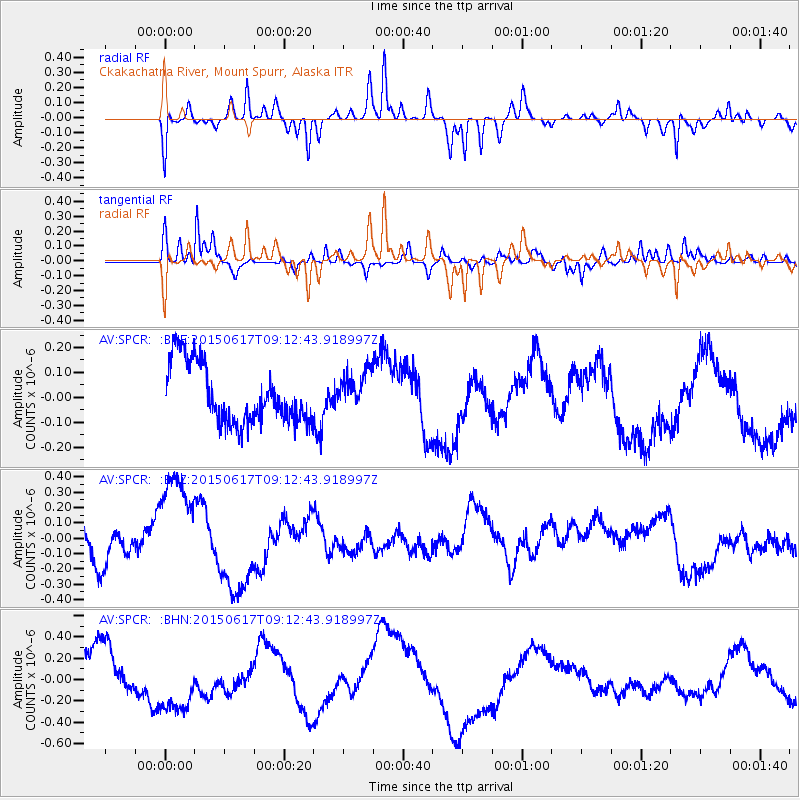
SPCR Ckakachatna River, Mount Spurr, Alaska - Earthquake Result Viewer
*The percent match for this event was below the threshold and hence no stack was calculated.
| Earthquake location: |
South Of Kermadec Islands |
| Earthquake latitude/longitude: |
-32.4/179.5 |
| Earthquake time(UTC): |
2015/06/17 (168) 09:00:29 GMT |
| Earthquake Depth: |
372 km |
| Earthquake Magnitude: |
4.6 mb |
| Earthquake Catalog/Contributor: |
ISC/ISC |
|
| Network: |
AV Alaska Volcano Observatory |
| Station: |
SPCR Ckakachatna River, Mount Spurr, Alaska |
| Lat/Lon: |
61.20 N/152.21 W |
| Elevation: |
984 m |
|
| Distance: |
96.0 deg |
| Az: |
13.33 deg |
| Baz: |
203.76 deg |
| Ray Param: |
$rayparam |
*The percent match for this event was below the threshold and hence was not used in the summary stack. |
|
| Radial Match: |
70.435265 % |
| Radial Bump: |
276 |
| Transverse Match: |
58.43909 % |
| Transverse Bump: |
310 |
| SOD ConfigId: |
7422571 |
| Insert Time: |
2019-04-19 09:06:29.727 +0000 |
| GWidth: |
2.5 |
| Max Bumps: |
400 |
| Tol: |
0.001 |
|
Signal To Noise
| Channel | StoN | STA | LTA |
| AV:SPCR: :BHZ:20150617T09:12:43.918997Z | 4.405713 | 3.7012913E-7 | 8.401118E-8 |
| AV:SPCR: :BHN:20150617T09:12:43.918997Z | 1.3668509 | 2.8513065E-7 | 2.0860406E-7 |
| AV:SPCR: :BHE:20150617T09:12:43.918997Z | 0.68833196 | 8.08154E-8 | 1.1740759E-7 |
| Arrivals |
| Ps | |
| PpPs | |
| PsPs/PpSs | |


