You are here: Home > Network List > UW - Pacific Northwest Regional Seismic Network Stations List
> Station PASS Maple Falls, WA, USA > Earthquake Result Viewer
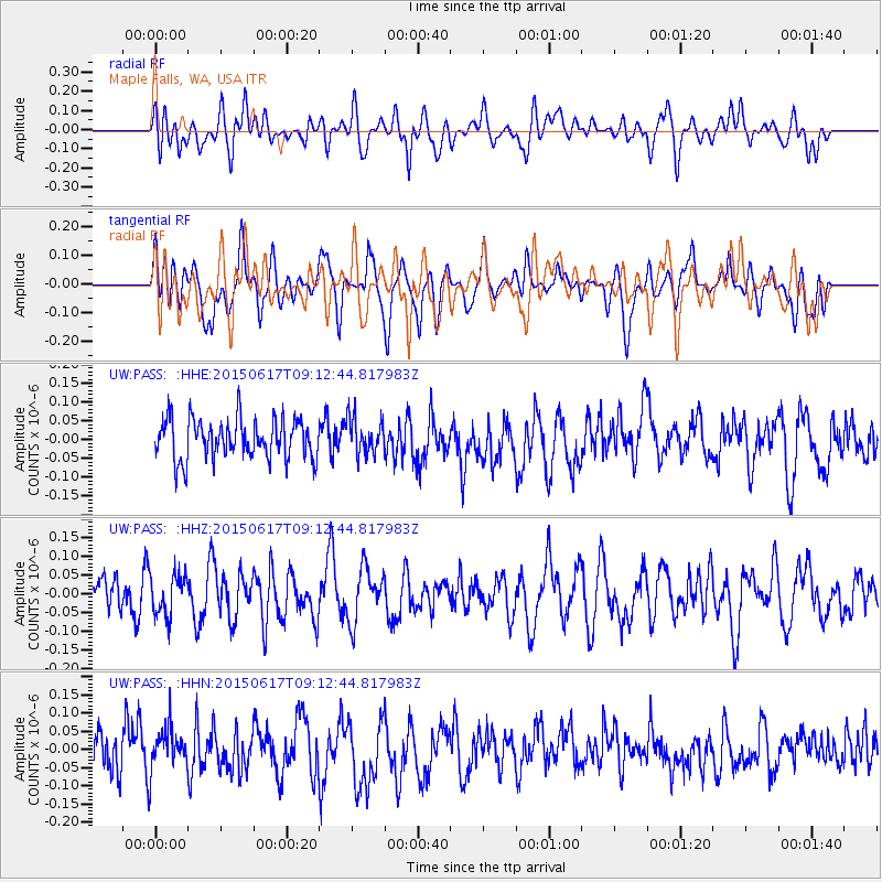
PASS Maple Falls, WA, USA - Earthquake Result Viewer
*The percent match for this event was below the threshold and hence no stack was calculated.
| Earthquake location: |
South Of Kermadec Islands |
| Earthquake latitude/longitude: |
-32.4/179.5 |
| Earthquake time(UTC): |
2015/06/17 (168) 09:00:29 GMT |
| Earthquake Depth: |
372 km |
| Earthquake Magnitude: |
4.6 mb |
| Earthquake Catalog/Contributor: |
ISC/ISC |
|
| Network: |
UW Pacific Northwest Regional Seismic Network |
| Station: |
PASS Maple Falls, WA, USA |
| Lat/Lon: |
49.00 N/122.09 W |
| Elevation: |
174 m |
|
| Distance: |
96.3 deg |
| Az: |
34.347 deg |
| Baz: |
226.462 deg |
| Ray Param: |
$rayparam |
*The percent match for this event was below the threshold and hence was not used in the summary stack. |
|
| Radial Match: |
43.158142 % |
| Radial Bump: |
400 |
| Transverse Match: |
52.80426 % |
| Transverse Bump: |
400 |
| SOD ConfigId: |
7422571 |
| Insert Time: |
2019-04-19 09:09:28.664 +0000 |
| GWidth: |
2.5 |
| Max Bumps: |
400 |
| Tol: |
0.001 |
|
Signal To Noise
| Channel | StoN | STA | LTA |
| UW:PASS: :HHZ:20150617T09:12:44.817983Z | 0.7655949 | 5.4084968E-8 | 7.064437E-8 |
| UW:PASS: :HHN:20150617T09:12:44.817983Z | 1.0715829 | 5.598274E-8 | 5.2243028E-8 |
| UW:PASS: :HHE:20150617T09:12:44.817983Z | 0.9018627 | 4.797956E-8 | 5.3200516E-8 |
| Arrivals |
| Ps | |
| PpPs | |
| PsPs/PpSs | |


