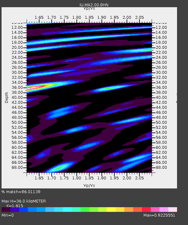
MA2 Magadan, Russia - Earthquake Result Viewer

Earthquake location: Northern Sumatra, Indonesia
Earthquake latitude/longitude: 0.4/97.8
Earthquake time(UTC): 2004/05/11 (132) 08:28:48 GMT
Earthquake Depth: 21 km
Earthquake Magnitude: 5.6 MB, 6.2 MS, 6.1 MW, 6.1 MW
Earthquake Catalog/Contributor: WHDF/NEIC
Network: IU Global Seismograph Network (GSN - IRIS/USGS)
Station: MA2 Magadan, Russia
Lat/Lon: 59.58 N/150.77 E
Elevation: 339 m
Distance: 71.8 deg
Az: 25.317 deg
Baz: 237.163 deg
Ray Param: 0.054085195
Estimated Moho Depth: 36.0 km
Estimated Crust Vp/Vs: 1.62
Assumed Crust Vp: 6.134 km/s
Estimated Crust Vs: 3.798 km/s
Estimated Crust Poisson's Ratio: 0.19
Radial Match: 96.01139 %
Radial Bump: 400
Transverse Match: 86.92167 %
Transverse Bump: 400
SOD ConfigId: 2459
Insert Time: 2010-03-03 14:46:57.218 +0000
GWidth: 2.5
Max Bumps: 400
Tol: 0.001

Signal To Noise

ChannelStoNSTALTA
IU:MA2:00:BHN:20040511T08:39:37.82303Z5.74541433.0782377E-75.3577295E-8
IU:MA2:00:BHE:20040511T08:39:37.82303Z11.6617554.9979224E-74.2857376E-8
IU:MA2:00:BHZ:20040511T08:39:37.82303Z18.4425581.3510776E-67.325868E-8
Arrivals
Ps3.7 SECOND
PpPs15 SECOND
PsPs/PpSs19 SECOND