You are here: Home > Network List > GS - US Geological Survey Networks Stations List
> Station KAN11 Stewart Ranch, Harper County, KS, USA > Earthquake Result Viewer
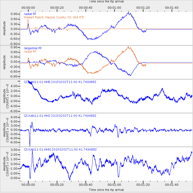
KAN11 Stewart Ranch, Harper County, KS, USA - Earthquake Result Viewer
*The percent match for this event was below the threshold and hence no stack was calculated.
| Earthquake location: |
Mendoza Province, Argentina |
| Earthquake latitude/longitude: |
-32.7/-67.1 |
| Earthquake time(UTC): |
2015/02/02 (033) 10:49:48 GMT |
| Earthquake Depth: |
172 km |
| Earthquake Magnitude: |
6.3 MO |
| Earthquake Catalog/Contributor: |
NEIC PDE/NEIC ALERT |
|
| Network: |
GS US Geological Survey Networks |
| Station: |
KAN11 Stewart Ranch, Harper County, KS, USA |
| Lat/Lon: |
37.21 N/97.91 W |
| Elevation: |
410 m |
|
| Distance: |
75.3 deg |
| Az: |
334.955 deg |
| Baz: |
153.451 deg |
| Ray Param: |
$rayparam |
*The percent match for this event was below the threshold and hence was not used in the summary stack. |
|
| Radial Match: |
55.4793 % |
| Radial Bump: |
400 |
| Transverse Match: |
62.986298 % |
| Transverse Bump: |
400 |
| SOD ConfigId: |
837871 |
| Insert Time: |
2015-02-16 11:12:59.365 +0000 |
| GWidth: |
2.5 |
| Max Bumps: |
400 |
| Tol: |
0.001 |
|
Signal To Noise
| Channel | StoN | STA | LTA |
| GS:KAN11:01:HHZ:20150202T11:00:41.749988Z | 17.873283 | 3.7415423E-6 | 2.0933716E-7 |
| GS:KAN11:01:HHN:20150202T11:00:41.749988Z | 0.9592854 | 1.3210881E-6 | 1.3771586E-6 |
| GS:KAN11:01:HHE:20150202T11:00:41.749988Z | 0.23767176 | 5.8987126E-7 | 2.4818737E-6 |
| Arrivals |
| Ps | |
| PpPs | |
| PsPs/PpSs | |


