You are here: Home > Network List > PE - Penn State Network Stations List
> Station PAGS PA Geological Survey, Middletown, PA > Earthquake Result Viewer
PAGS PA Geological Survey, Middletown, PA - Earthquake Result Viewer
| Earthquake location: |
Southern Mid-Atlantic Ridge |
| Earthquake latitude/longitude: |
-35.4/-17.4 |
| Earthquake time(UTC): |
2015/06/17 (168) 12:51:33 GMT |
| Earthquake Depth: |
10 km |
| Earthquake Magnitude: |
6.1 MB |
| Earthquake Catalog/Contributor: |
NEIC PDE/NEIC ALERT |
|
| Network: |
PE Penn State Network |
| Station: |
PAGS PA Geological Survey, Middletown, PA |
| Lat/Lon: |
40.23 N/76.72 W |
| Elevation: |
120 m |
|
| Distance: |
92.9 deg |
| Az: |
318.758 deg |
| Baz: |
135.265 deg |
| Ray Param: |
0.041359823 |
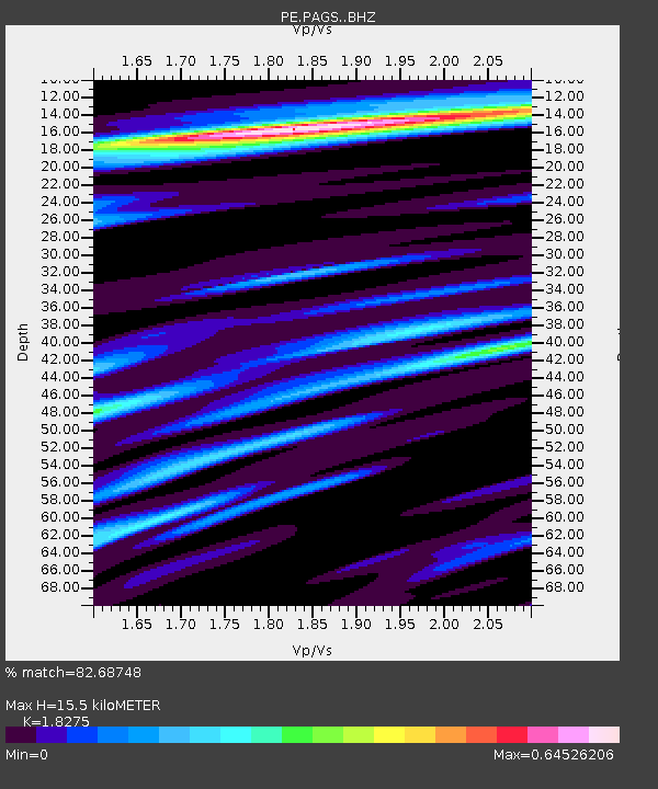
| Estimated Moho Depth: |
15.5 km |
| Estimated Crust Vp/Vs: |
1.83 |
| Assumed Crust Vp: |
6.121 km/s |
| Estimated Crust Vs: |
3.349 km/s |
| Estimated Crust Poisson's Ratio: |
0.29 |
|
| Radial Match: |
82.68748 % |
| Radial Bump: |
400 |
| Transverse Match: |
67.29055 % |
| Transverse Bump: |
400 |
| SOD ConfigId: |
7422571 |
| Insert Time: |
2019-04-19 09:13:06.064 +0000 |
| GWidth: |
2.5 |
| Max Bumps: |
400 |
| Tol: |
0.001 |
|

Signal To Noise
| Channel | StoN | STA | LTA |
| PE:PAGS: :BHZ:20150617T13:04:13.819995Z | 1.4268365 | 1.6114785E-7 | 1.12940654E-7 |
| PE:PAGS: :BHN:20150617T13:04:13.819995Z | 1.4983163 | 2.100383E-7 | 1.4018289E-7 |
| PE:PAGS: :BHE:20150617T13:04:13.819995Z | 0.8287543 | 1.0297604E-7 | 1.24254E-7 |
| Arrivals |
| Ps | 2.1 SECOND |
| PpPs | 7.0 SECOND |
| PsPs/PpSs | 9.2 SECOND |


