You are here: Home > Network List > YT07 - POLENET Stations List
> Station ALYS ALYS > Earthquake Result Viewer
ALYS ALYS - Earthquake Result Viewer
| Earthquake location: |
Southern Mid-Atlantic Ridge |
| Earthquake latitude/longitude: |
-35.4/-17.4 |
| Earthquake time(UTC): |
2015/06/17 (168) 12:51:33 GMT |
| Earthquake Depth: |
10 km |
| Earthquake Magnitude: |
6.1 MB |
| Earthquake Catalog/Contributor: |
NEIC PDE/NEIC ALERT |
|
| Network: |
YT POLENET |
| Station: |
ALYS ALYS |
| Lat/Lon: |
84.35 S/23.73 W |
| Elevation: |
2084 m |
|
| Distance: |
49.2 deg |
| Az: |
180.826 deg |
| Baz: |
6.835 deg |
| Ray Param: |
0.06886752 |
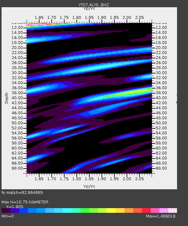
| Estimated Moho Depth: |
10.75 km |
| Estimated Crust Vp/Vs: |
1.61 |
| Assumed Crust Vp: |
6.356 km/s |
| Estimated Crust Vs: |
3.96 km/s |
| Estimated Crust Poisson's Ratio: |
0.18 |
|
| Radial Match: |
92.994995 % |
| Radial Bump: |
388 |
| Transverse Match: |
87.28571 % |
| Transverse Bump: |
400 |
| SOD ConfigId: |
7422571 |
| Insert Time: |
2019-04-19 09:14:30.102 +0000 |
| GWidth: |
2.5 |
| Max Bumps: |
400 |
| Tol: |
0.001 |
|

Signal To Noise
| Channel | StoN | STA | LTA |
| YT:ALYS: :BHZ:20150617T12:59:50.374988Z | 1.7435769 | 4.733637E-7 | 2.7149002E-7 |
| YT:ALYS: :BHN:20150617T12:59:50.374988Z | 1.1470376 | 2.918605E-7 | 2.544472E-7 |
| YT:ALYS: :BHE:20150617T12:59:50.374988Z | 0.79572517 | 1.3959267E-7 | 1.7542826E-7 |
| Arrivals |
| Ps | 1.1 SECOND |
| PpPs | 4.1 SECOND |
| PsPs/PpSs | 5.2 SECOND |


