You are here: Home > Network List > IU - Global Seismograph Network (GSN - IRIS/USGS) Stations List
> Station MA2 Magadan, Russia > Earthquake Result Viewer
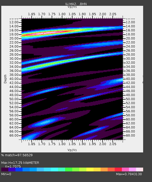
MA2 Magadan, Russia - Earthquake Result Viewer
| Earthquake location: |
South Of Java, Indonesia |
| Earthquake latitude/longitude: |
-10.5/112.9 |
| Earthquake time(UTC): |
1994/06/03 (154) 21:06:57 GMT |
| Earthquake Depth: |
16 km |
| Earthquake Magnitude: |
5.9 MB, 6.4 MS, 6.3 UNKNOWN, 6.6 MW |
| Earthquake Catalog/Contributor: |
WHDF/NEIC |
|
| Network: |
IU Global Seismograph Network (GSN - IRIS/USGS) |
| Station: |
MA2 Magadan, Russia |
| Lat/Lon: |
59.58 N/150.77 E |
| Elevation: |
339 m |
|
| Distance: |
76.2 deg |
| Az: |
18.781 deg |
| Baz: |
218.475 deg |
| Ray Param: |
0.05117185 |
| Estimated Moho Depth: |
17.25 km |
| Estimated Crust Vp/Vs: |
1.71 |
| Assumed Crust Vp: |
6.134 km/s |
| Estimated Crust Vs: |
3.592 km/s |
| Estimated Crust Poisson's Ratio: |
0.24 |
|
| Radial Match: |
97.56529 % |
| Radial Bump: |
400 |
| Transverse Match: |
91.11118 % |
| Transverse Bump: |
400 |
| SOD ConfigId: |
16938 |
| Insert Time: |
2010-03-03 14:48:30.065 +0000 |
| GWidth: |
2.5 |
| Max Bumps: |
400 |
| Tol: |
0.001 |
|

Signal To Noise
| Channel | StoN | STA | LTA |
| IU:MA2: :BHN:19940603T21:18:13.107007Z | 4.555242 | 1.9336024E-7 | 4.244785E-8 |
| IU:MA2: :BHE:19940603T21:18:13.107007Z | 3.5875854 | 1.4931928E-7 | 4.1621107E-8 |
| IU:MA2: :BHZ:19940603T21:18:13.107007Z | 10.284953 | 6.7796447E-7 | 6.591809E-8 |
| Arrivals |
| Ps | 2.0 SECOND |
| PpPs | 7.4 SECOND |
| PsPs/PpSs | 9.4 SECOND |


