You are here: Home > Network List > IU - Global Seismograph Network (GSN - IRIS/USGS) Stations List
> Station MA2 Magadan, Russia > Earthquake Result Viewer
MA2 Magadan, Russia - Earthquake Result Viewer
| Earthquake location: |
South Of Java, Indonesia |
| Earthquake latitude/longitude: |
-10.8/113.4 |
| Earthquake time(UTC): |
1994/06/04 (155) 00:57:53 GMT |
| Earthquake Depth: |
33 km |
| Earthquake Magnitude: |
5.8 MB, 6.2 MS, 6.0 UNKNOWN |
| Earthquake Catalog/Contributor: |
WHDF/NEIC |
|
| Network: |
IU Global Seismograph Network (GSN - IRIS/USGS) |
| Station: |
MA2 Magadan, Russia |
| Lat/Lon: |
59.58 N/150.77 E |
| Elevation: |
339 m |
|
| Distance: |
76.3 deg |
| Az: |
18.534 deg |
| Baz: |
217.858 deg |
| Ray Param: |
0.051072102 |
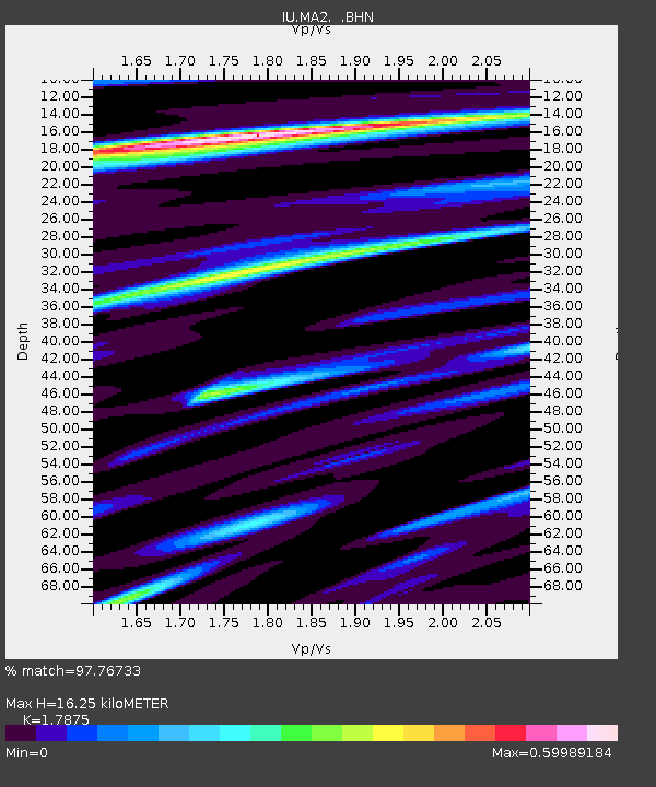
| Estimated Moho Depth: |
16.25 km |
| Estimated Crust Vp/Vs: |
1.79 |
| Assumed Crust Vp: |
6.134 km/s |
| Estimated Crust Vs: |
3.432 km/s |
| Estimated Crust Poisson's Ratio: |
0.27 |
|
| Radial Match: |
97.76733 % |
| Radial Bump: |
400 |
| Transverse Match: |
94.02608 % |
| Transverse Bump: |
400 |
| SOD ConfigId: |
16938 |
| Insert Time: |
2010-03-03 14:48:32.581 +0000 |
| GWidth: |
2.5 |
| Max Bumps: |
400 |
| Tol: |
0.001 |
|

Signal To Noise
| Channel | StoN | STA | LTA |
| IU:MA2: :BHN:19940604T01:09:07.757019Z | 4.5132504 | 2.2570565E-7 | 5.0009557E-8 |
| IU:MA2: :BHE:19940604T01:09:07.757019Z | 4.17304 | 1.6239655E-7 | 3.8915644E-8 |
| IU:MA2: :BHZ:19940604T01:09:07.757019Z | 17.653477 | 7.420115E-7 | 4.2032028E-8 |
| Arrivals |
| Ps | 2.1 SECOND |
| PpPs | 7.2 SECOND |
| PsPs/PpSs | 9.3 SECOND |


