You are here: Home > Network List > US - United States National Seismic Network Stations List
> Station HAWA Hanford, Washington, USA > Earthquake Result Viewer
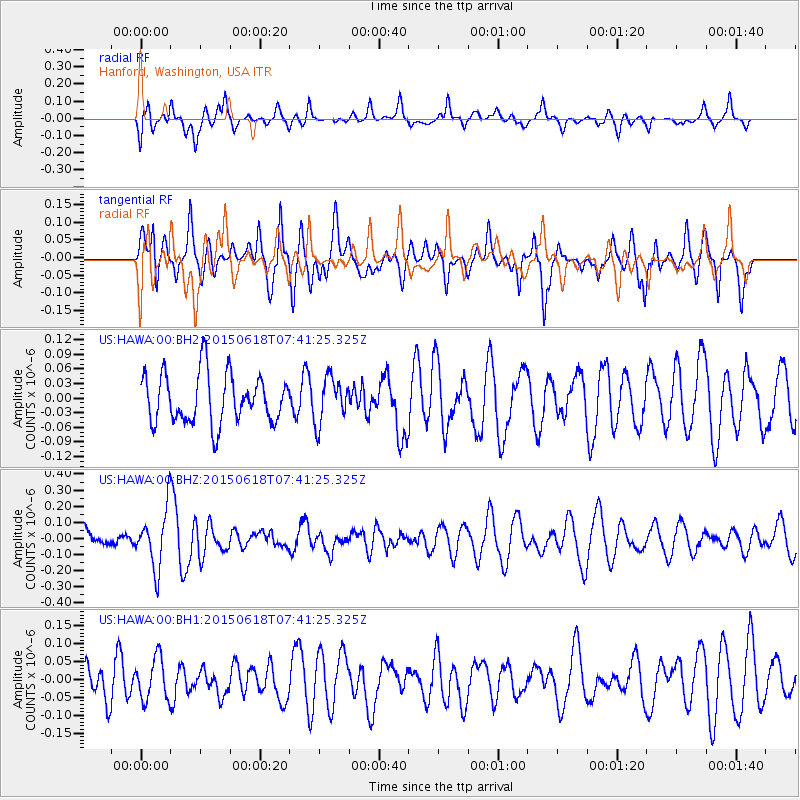
HAWA Hanford, Washington, USA - Earthquake Result Viewer
*The percent match for this event was below the threshold and hence no stack was calculated.
| Earthquake location: |
Vanuatu Islands |
| Earthquake latitude/longitude: |
-19.2/169.8 |
| Earthquake time(UTC): |
2015/06/18 (169) 07:28:55 GMT |
| Earthquake Depth: |
35 km |
| Earthquake Magnitude: |
5.4 MW |
| Earthquake Catalog/Contributor: |
ISC/ISC |
|
| Network: |
US United States National Seismic Network |
| Station: |
HAWA Hanford, Washington, USA |
| Lat/Lon: |
46.39 N/119.53 W |
| Elevation: |
364 m |
|
| Distance: |
91.1 deg |
| Az: |
40.801 deg |
| Baz: |
243.158 deg |
| Ray Param: |
$rayparam |
*The percent match for this event was below the threshold and hence was not used in the summary stack. |
|
| Radial Match: |
60.75194 % |
| Radial Bump: |
400 |
| Transverse Match: |
52.46755 % |
| Transverse Bump: |
393 |
| SOD ConfigId: |
7422571 |
| Insert Time: |
2019-04-19 09:22:41.762 +0000 |
| GWidth: |
2.5 |
| Max Bumps: |
400 |
| Tol: |
0.001 |
|
Signal To Noise
| Channel | StoN | STA | LTA |
| US:HAWA:00:BHZ:20150618T07:41:25.325Z | 2.6767855 | 1.7928281E-7 | 6.697691E-8 |
| US:HAWA:00:BH1:20150618T07:41:25.325Z | 0.8997449 | 5.901444E-8 | 6.5590186E-8 |
| US:HAWA:00:BH2:20150618T07:41:25.325Z | 0.9108298 | 4.6012016E-8 | 5.0516594E-8 |
| Arrivals |
| Ps | |
| PpPs | |
| PsPs/PpSs | |


