You are here: Home > Network List > IU - Global Seismograph Network (GSN - IRIS/USGS) Stations List
> Station MA2 Magadan, Russia > Earthquake Result Viewer
MA2 Magadan, Russia - Earthquake Result Viewer

| Earthquake location: |
Halmahera, Indonesia |
| Earthquake latitude/longitude: |
-1.4/127.5 |
| Earthquake time(UTC): |
1995/02/13 (044) 15:04:26 GMT |
| Earthquake Depth: |
33 km |
| Earthquake Magnitude: |
6.2 MB, 6.8 MS, 6.8 UNKNOWN, 6.7 MW |
| Earthquake Catalog/Contributor: |
WHDF/NEIC |
|
| Network: |
IU Global Seismograph Network (GSN - IRIS/USGS) |
| Station: |
MA2 Magadan, Russia |
| Lat/Lon: |
59.58 N/150.77 E |
| Elevation: |
339 m |
|
| Distance: |
63.4 deg |
| Az: |
12.98 deg |
| Baz: |
206.181 deg |
| Ray Param: |
0.059529867 |
| Estimated Moho Depth: |
22.5 km |
| Estimated Crust Vp/Vs: |
2.04 |
| Assumed Crust Vp: |
6.134 km/s |
| Estimated Crust Vs: |
3.003 km/s |
| Estimated Crust Poisson's Ratio: |
0.34 |
|
| Radial Match: |
97.145515 % |
| Radial Bump: |
326 |
| Transverse Match: |
87.446915 % |
| Transverse Bump: |
400 |
| SOD ConfigId: |
6273 |
| Insert Time: |
2010-03-03 14:49:33.180 +0000 |
| GWidth: |
2.5 |
| Max Bumps: |
400 |
| Tol: |
0.001 |
|
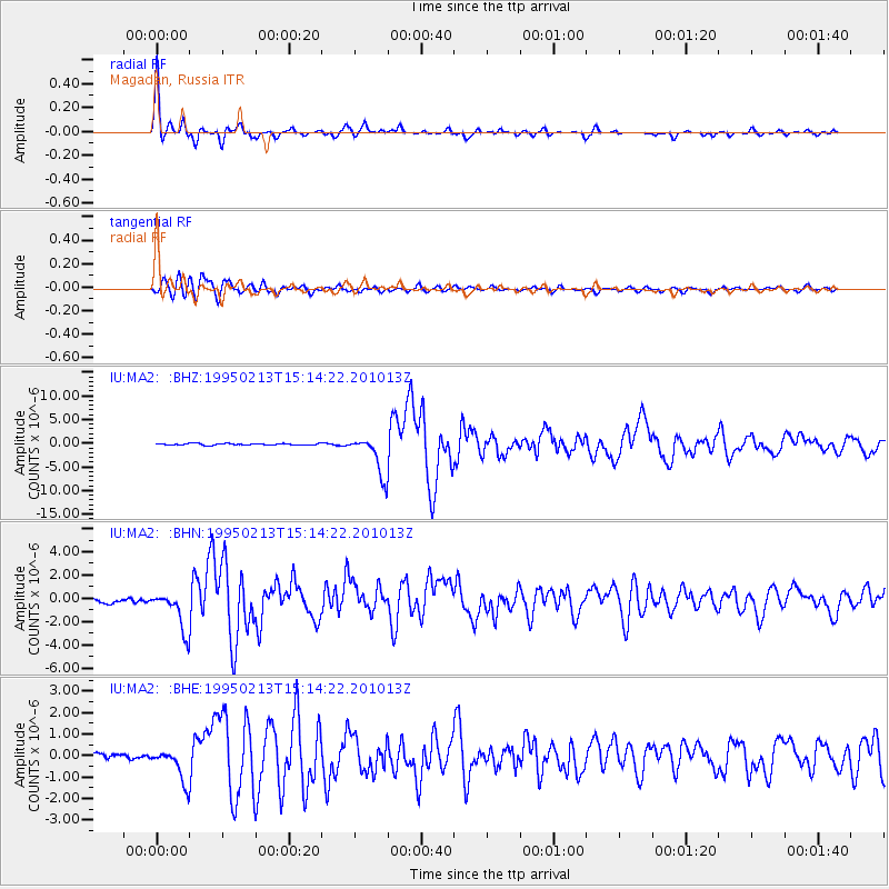
Signal To Noise
| Channel | StoN | STA | LTA |
| IU:MA2: :BHN:19950213T15:14:22.201013Z | 6.276836 | 1.6872534E-6 | 2.6880636E-7 |
| IU:MA2: :BHE:19950213T15:14:22.201013Z | 5.0576015 | 7.6199507E-7 | 1.5066333E-7 |
| IU:MA2: :BHZ:19950213T15:14:22.201013Z | 26.170095 | 4.1867147E-6 | 1.5998087E-7 |
| Arrivals |
| Ps | 4.0 SECOND |
| PpPs | 11 SECOND |
| PsPs/PpSs | 15 SECOND |


