You are here: Home > Network List > TA - USArray Transportable Network (new EarthScope stations) Stations List
> Station L04D Klamath Falls, OR, USA > Earthquake Result Viewer
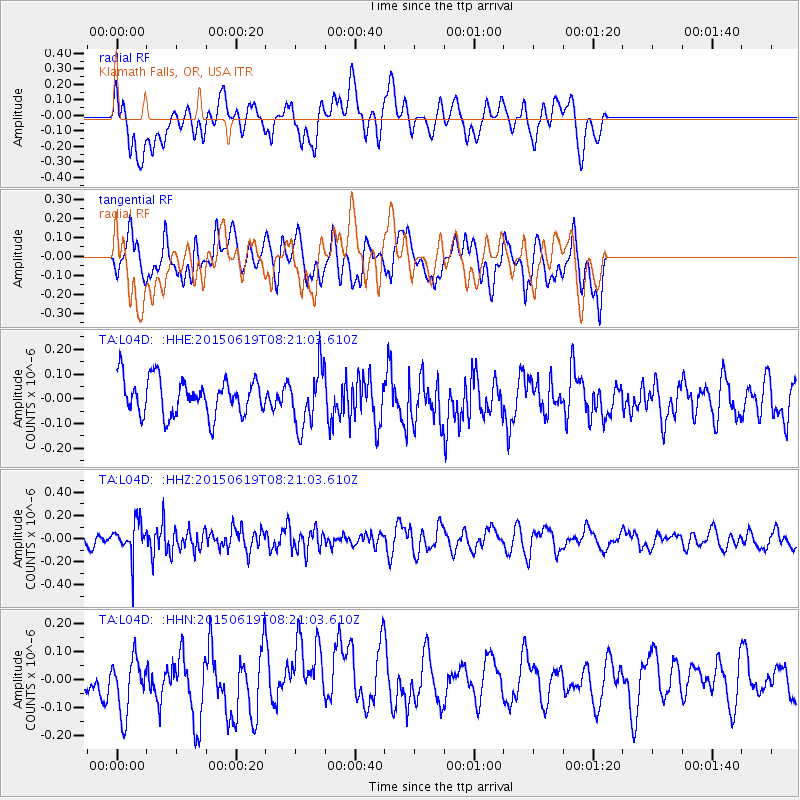
L04D Klamath Falls, OR, USA - Earthquake Result Viewer
*The percent match for this event was below the threshold and hence no stack was calculated.
| Earthquake location: |
Bonin Islands, Japan Region |
| Earthquake latitude/longitude: |
27.0/143.8 |
| Earthquake time(UTC): |
2015/06/19 (170) 08:09:54 GMT |
| Earthquake Depth: |
19 km |
| Earthquake Magnitude: |
4.9 MW |
| Earthquake Catalog/Contributor: |
ISC/ISC |
|
| Network: |
TA USArray Transportable Network (new EarthScope stations) |
| Station: |
L04D Klamath Falls, OR, USA |
| Lat/Lon: |
42.22 N/122.30 W |
| Elevation: |
1437 m |
|
| Distance: |
75.1 deg |
| Az: |
50.078 deg |
| Baz: |
292.934 deg |
| Ray Param: |
$rayparam |
*The percent match for this event was below the threshold and hence was not used in the summary stack. |
|
| Radial Match: |
50.832165 % |
| Radial Bump: |
400 |
| Transverse Match: |
42.024483 % |
| Transverse Bump: |
400 |
| SOD ConfigId: |
7422571 |
| Insert Time: |
2019-04-19 09:34:46.007 +0000 |
| GWidth: |
2.5 |
| Max Bumps: |
400 |
| Tol: |
0.001 |
|
Signal To Noise
| Channel | StoN | STA | LTA |
| TA:L04D: :HHZ:20150619T08:21:03.610Z | 2.1575325 | 1.5054746E-7 | 6.977761E-8 |
| TA:L04D: :HHN:20150619T08:21:03.610Z | 1.4709263 | 1.071826E-7 | 7.286742E-8 |
| TA:L04D: :HHE:20150619T08:21:03.610Z | 1.5607064 | 1.1487267E-7 | 7.3603E-8 |
| Arrivals |
| Ps | |
| PpPs | |
| PsPs/PpSs | |


