You are here: Home > Network List > US - United States National Seismic Network Stations List
> Station AMTX Amarillo, Texas, USA > Earthquake Result Viewer
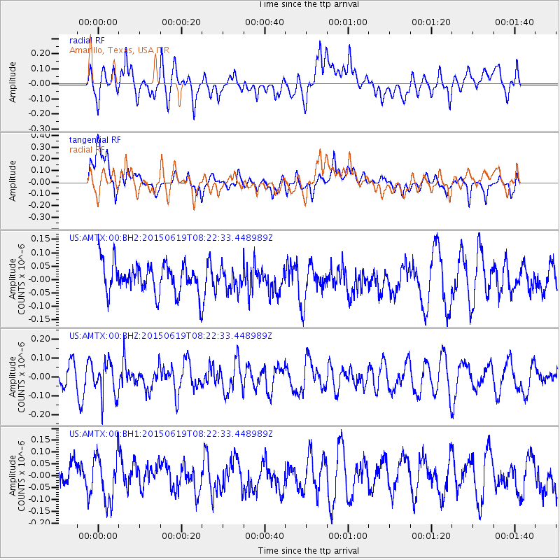
AMTX Amarillo, Texas, USA - Earthquake Result Viewer
*The percent match for this event was below the threshold and hence no stack was calculated.
| Earthquake location: |
Bonin Islands, Japan Region |
| Earthquake latitude/longitude: |
27.0/143.8 |
| Earthquake time(UTC): |
2015/06/19 (170) 08:09:54 GMT |
| Earthquake Depth: |
19 km |
| Earthquake Magnitude: |
4.9 MW |
| Earthquake Catalog/Contributor: |
ISC/ISC |
|
| Network: |
US United States National Seismic Network |
| Station: |
AMTX Amarillo, Texas, USA |
| Lat/Lon: |
34.53 N/101.41 W |
| Elevation: |
1010 m |
|
| Distance: |
93.1 deg |
| Az: |
48.631 deg |
| Baz: |
305.82 deg |
| Ray Param: |
$rayparam |
*The percent match for this event was below the threshold and hence was not used in the summary stack. |
|
| Radial Match: |
42.982735 % |
| Radial Bump: |
400 |
| Transverse Match: |
61.78541 % |
| Transverse Bump: |
400 |
| SOD ConfigId: |
7422571 |
| Insert Time: |
2019-04-19 09:35:14.683 +0000 |
| GWidth: |
2.5 |
| Max Bumps: |
400 |
| Tol: |
0.001 |
|
Signal To Noise
| Channel | StoN | STA | LTA |
| US:AMTX:00:BHZ:20150619T08:22:33.448989Z | 1.2266251 | 9.113919E-8 | 7.430078E-8 |
| US:AMTX:00:BH1:20150619T08:22:33.448989Z | 1.5254824 | 1.0213052E-7 | 6.694965E-8 |
| US:AMTX:00:BH2:20150619T08:22:33.448989Z | 0.8171759 | 4.4661093E-8 | 5.4652972E-8 |
| Arrivals |
| Ps | |
| PpPs | |
| PsPs/PpSs | |


