You are here: Home > Network List > US - United States National Seismic Network Stations List
> Station DGMT Dagmar, Montana, USA > Earthquake Result Viewer
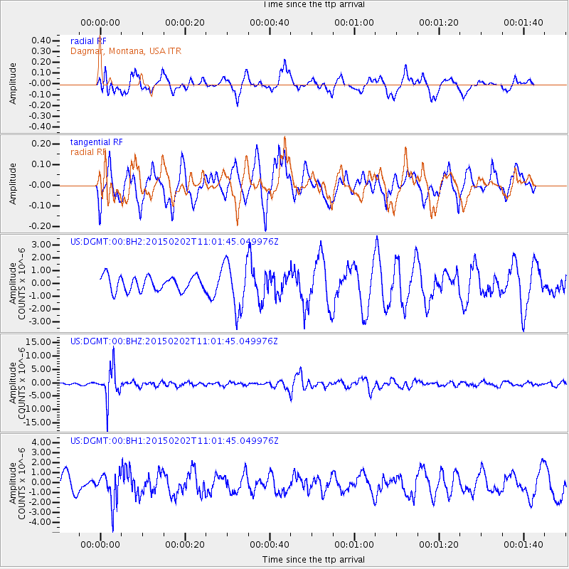
DGMT Dagmar, Montana, USA - Earthquake Result Viewer
*The percent match for this event was below the threshold and hence no stack was calculated.
| Earthquake location: |
Mendoza Province, Argentina |
| Earthquake latitude/longitude: |
-32.7/-67.1 |
| Earthquake time(UTC): |
2015/02/02 (033) 10:49:48 GMT |
| Earthquake Depth: |
172 km |
| Earthquake Magnitude: |
6.3 MO |
| Earthquake Catalog/Contributor: |
NEIC PDE/NEIC ALERT |
|
| Network: |
US United States National Seismic Network |
| Station: |
DGMT Dagmar, Montana, USA |
| Lat/Lon: |
48.47 N/104.20 W |
| Elevation: |
0.0 m |
|
| Distance: |
87.4 deg |
| Az: |
336.286 deg |
| Baz: |
149.373 deg |
| Ray Param: |
$rayparam |
*The percent match for this event was below the threshold and hence was not used in the summary stack. |
|
| Radial Match: |
60.360447 % |
| Radial Bump: |
400 |
| Transverse Match: |
38.093357 % |
| Transverse Bump: |
356 |
| SOD ConfigId: |
837871 |
| Insert Time: |
2015-02-16 11:16:43.096 +0000 |
| GWidth: |
2.5 |
| Max Bumps: |
400 |
| Tol: |
0.001 |
|
Signal To Noise
| Channel | StoN | STA | LTA |
| US:DGMT:00:BHZ:20150202T11:01:45.049976Z | 14.275556 | 5.762689E-6 | 4.036753E-7 |
| US:DGMT:00:BH1:20150202T11:01:45.049976Z | 0.96102494 | 1.5190407E-6 | 1.5806465E-6 |
| US:DGMT:00:BH2:20150202T11:01:45.049976Z | 3.332343 | 1.914754E-6 | 5.745969E-7 |
| Arrivals |
| Ps | |
| PpPs | |
| PsPs/PpSs | |


