You are here: Home > Network List > IU - Global Seismograph Network (GSN - IRIS/USGS) Stations List
> Station MA2 Magadan, Russia > Earthquake Result Viewer
MA2 Magadan, Russia - Earthquake Result Viewer

| Earthquake location: |
Sulawesi, Indonesia |
| Earthquake latitude/longitude: |
-5.6/122.1 |
| Earthquake time(UTC): |
2005/02/19 (050) 00:04:43 GMT |
| Earthquake Depth: |
10 km |
| Earthquake Magnitude: |
6.3 MB, 6.3 MS, 6.5 MW, 6.4 MW |
| Earthquake Catalog/Contributor: |
WHDF/NEIC |
|
| Network: |
IU Global Seismograph Network (GSN - IRIS/USGS) |
| Station: |
MA2 Magadan, Russia |
| Lat/Lon: |
59.58 N/150.77 E |
| Elevation: |
339 m |
|
| Distance: |
68.8 deg |
| Az: |
15.168 deg |
| Baz: |
210.78 deg |
| Ray Param: |
0.05607026 |
| Estimated Moho Depth: |
17.0 km |
| Estimated Crust Vp/Vs: |
1.76 |
| Assumed Crust Vp: |
6.134 km/s |
| Estimated Crust Vs: |
3.49 km/s |
| Estimated Crust Poisson's Ratio: |
0.26 |
|
| Radial Match: |
96.20901 % |
| Radial Bump: |
333 |
| Transverse Match: |
91.7509 % |
| Transverse Bump: |
304 |
| SOD ConfigId: |
2455 |
| Insert Time: |
2010-03-03 14:52:07.821 +0000 |
| GWidth: |
2.5 |
| Max Bumps: |
400 |
| Tol: |
0.001 |
|
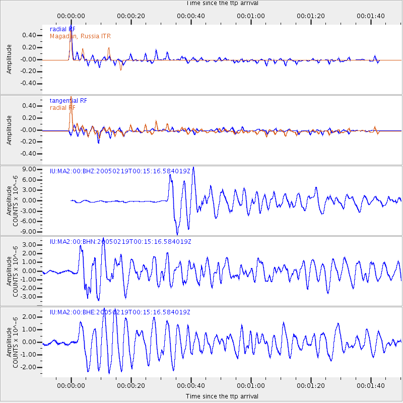
Signal To Noise
| Channel | StoN | STA | LTA |
| IU:MA2:00:BHN:20050219T00:15:16.584019Z | 10.881941 | 1.3439942E-6 | 1.2350685E-7 |
| IU:MA2:00:BHE:20050219T00:15:16.584019Z | 5.4059453 | 7.27961E-7 | 1.3465933E-7 |
| IU:MA2:00:BHZ:20050219T00:15:16.584019Z | 20.619967 | 3.4520754E-6 | 1.674142E-7 |
| Arrivals |
| Ps | 2.2 SECOND |
| PpPs | 7.4 SECOND |
| PsPs/PpSs | 9.6 SECOND |


