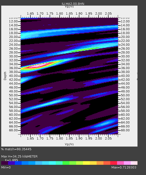
MA2 Magadan, Russia - Earthquake Result Viewer

Earthquake location: Northern Sumatra, Indonesia
Earthquake latitude/longitude: 2.1/97.1
Earthquake time(UTC): 2005/03/28 (087) 16:09:36 GMT
Earthquake Depth: 30 km
Earthquake Magnitude: 7.2 MB, 8.4 MS, 8.7 MW, 8.1 MW
Earthquake Catalog/Contributor: WHDF/NEIC
Network: IU Global Seismograph Network (GSN - IRIS/USGS)
Station: MA2 Magadan, Russia
Lat/Lon: 59.58 N/150.77 E
Elevation: 339 m
Distance: 70.6 deg
Az: 25.766 deg
Baz: 238.602 deg
Ray Param: 0.05484529
Estimated Moho Depth: 34.25 km
Estimated Crust Vp/Vs: 1.70
Assumed Crust Vp: 6.134 km/s
Estimated Crust Vs: 3.619 km/s
Estimated Crust Poisson's Ratio: 0.23
Radial Match: 98.35445 %
Radial Bump: 306
Transverse Match: 89.36546 %
Transverse Bump: 400
SOD ConfigId: 2459
Insert Time: 2010-03-03 14:52:18.149 +0000
GWidth: 2.5
Max Bumps: 400
Tol: 0.001

Signal To Noise

ChannelStoNSTALTA
IU:MA2:00:BHN:20050328T16:20:17.785005Z5.67259451.0393667E-61.8322599E-7
IU:MA2:00:BHE:20050328T16:20:17.785005Z5.09177831.4004507E-62.7504157E-7
IU:MA2:00:BHZ:20050328T16:20:17.785005Z3.78096843.3257522E-68.7960325E-7
Arrivals
Ps4.0 SECOND
PpPs15 SECOND
PsPs/PpSs19 SECOND