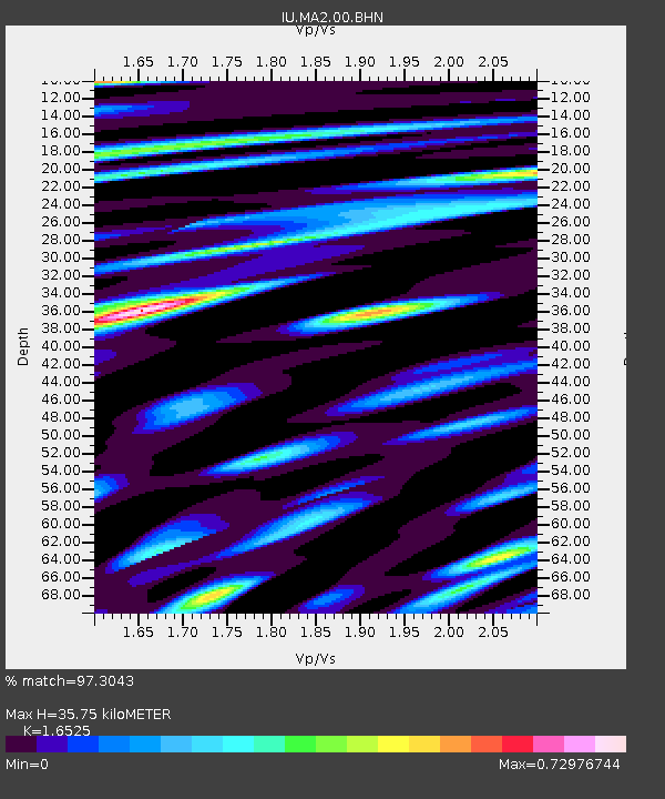
MA2 Magadan, Russia - Earthquake Result Viewer

Earthquake location: Northern Sumatra, Indonesia
Earthquake latitude/longitude: 1.8/97.1
Earthquake time(UTC): 2005/07/05 (186) 01:52:02 GMT
Earthquake Depth: 21 km
Earthquake Magnitude: 6.2 MB, 6.8 MS, 6.7 MW, 6.6 MW
Earthquake Catalog/Contributor: WHDF/NEIC
Network: IU Global Seismograph Network (GSN - IRIS/USGS)
Station: MA2 Magadan, Russia
Lat/Lon: 59.58 N/150.77 E
Elevation: 339 m
Distance: 70.8 deg
Az: 25.733 deg
Baz: 238.505 deg
Ray Param: 0.054700714
Estimated Moho Depth: 35.75 km
Estimated Crust Vp/Vs: 1.65
Assumed Crust Vp: 6.134 km/s
Estimated Crust Vs: 3.712 km/s
Estimated Crust Poisson's Ratio: 0.21
Radial Match: 97.3043 %
Radial Bump: 400
Transverse Match: 95.14695 %
Transverse Bump: 400
SOD ConfigId: 2475
Insert Time: 2010-03-03 14:52:38.798 +0000
GWidth: 2.5
Max Bumps: 400
Tol: 0.001

Signal To Noise

ChannelStoNSTALTA
IU:MA2:00:BHN:20050705T02:02:46.811023Z12.8320131.267694E-69.879152E-8
IU:MA2:00:BHE:20050705T02:02:46.811023Z19.0532532.159282E-61.13328795E-7
IU:MA2:00:BHZ:20050705T02:02:46.811023Z52.867195.5491128E-61.0496326E-7
Arrivals
Ps3.9 SECOND
PpPs15 SECOND
PsPs/PpSs19 SECOND