You are here: Home > Network List > TA - USArray Transportable Network (new EarthScope stations) Stations List
> Station A04D Lummi Island, WA, USA > Earthquake Result Viewer
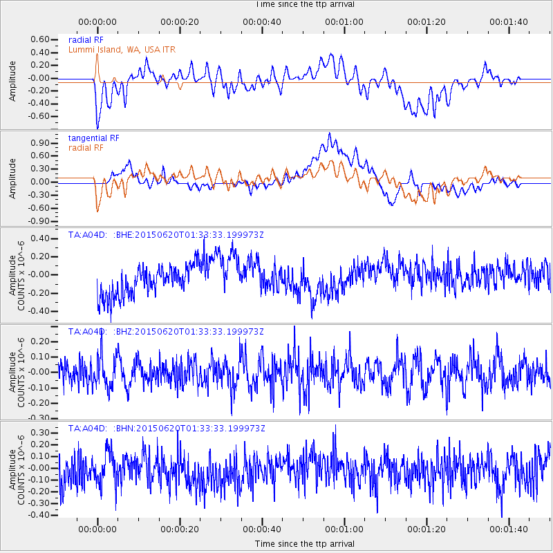
A04D Lummi Island, WA, USA - Earthquake Result Viewer
*The percent match for this event was below the threshold and hence no stack was calculated.
| Earthquake location: |
South Of Tonga Islands |
| Earthquake latitude/longitude: |
-24.6/-175.6 |
| Earthquake time(UTC): |
2015/06/20 (171) 01:21:21 GMT |
| Earthquake Depth: |
19 km |
| Earthquake Magnitude: |
4.7 mb |
| Earthquake Catalog/Contributor: |
ISC/ISC |
|
| Network: |
TA USArray Transportable Network (new EarthScope stations) |
| Station: |
A04D Lummi Island, WA, USA |
| Lat/Lon: |
48.72 N/122.71 W |
| Elevation: |
13 m |
|
| Distance: |
86.9 deg |
| Az: |
31.92 deg |
| Baz: |
226.637 deg |
| Ray Param: |
$rayparam |
*The percent match for this event was below the threshold and hence was not used in the summary stack. |
|
| Radial Match: |
34.189068 % |
| Radial Bump: |
400 |
| Transverse Match: |
26.634523 % |
| Transverse Bump: |
400 |
| SOD ConfigId: |
7422571 |
| Insert Time: |
2019-04-19 09:41:27.285 +0000 |
| GWidth: |
2.5 |
| Max Bumps: |
400 |
| Tol: |
0.001 |
|
Signal To Noise
| Channel | StoN | STA | LTA |
| TA:A04D: :BHZ:20150620T01:33:33.199973Z | 1.4021738 | 1.0508917E-7 | 7.494733E-8 |
| TA:A04D: :BHN:20150620T01:33:33.199973Z | 0.9667885 | 1.6396689E-7 | 1.6959955E-7 |
| TA:A04D: :BHE:20150620T01:33:33.199973Z | 1.7283748 | 2.6656312E-7 | 1.542276E-7 |
| Arrivals |
| Ps | |
| PpPs | |
| PsPs/PpSs | |


