You are here: Home > Network List > TA - USArray Transportable Network (new EarthScope stations) Stations List
> Station O03E Paynes Creek, CA, USA > Earthquake Result Viewer
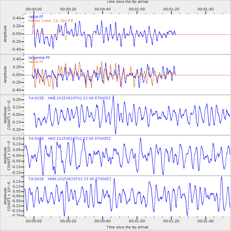
O03E Paynes Creek, CA, USA - Earthquake Result Viewer
*The percent match for this event was below the threshold and hence no stack was calculated.
| Earthquake location: |
South Of Tonga Islands |
| Earthquake latitude/longitude: |
-24.6/-175.6 |
| Earthquake time(UTC): |
2015/06/20 (171) 01:21:21 GMT |
| Earthquake Depth: |
19 km |
| Earthquake Magnitude: |
4.7 mb |
| Earthquake Catalog/Contributor: |
ISC/ISC |
|
| Network: |
TA USArray Transportable Network (new EarthScope stations) |
| Station: |
O03E Paynes Creek, CA, USA |
| Lat/Lon: |
40.29 N/121.80 W |
| Elevation: |
967 m |
|
| Distance: |
81.6 deg |
| Az: |
38.58 deg |
| Baz: |
227.937 deg |
| Ray Param: |
$rayparam |
*The percent match for this event was below the threshold and hence was not used in the summary stack. |
|
| Radial Match: |
49.665108 % |
| Radial Bump: |
400 |
| Transverse Match: |
50.96897 % |
| Transverse Bump: |
400 |
| SOD ConfigId: |
7422571 |
| Insert Time: |
2019-04-19 09:41:37.851 +0000 |
| GWidth: |
2.5 |
| Max Bumps: |
400 |
| Tol: |
0.001 |
|
Signal To Noise
| Channel | StoN | STA | LTA |
| TA:O03E: :HHZ:20150620T01:33:06.670005Z | 1.2738119 | 6.15407E-8 | 4.8312238E-8 |
| TA:O03E: :HHN:20150620T01:33:06.670005Z | 1.0707608 | 6.164693E-8 | 5.757302E-8 |
| TA:O03E: :HHE:20150620T01:33:06.670005Z | 0.88399416 | 5.9531356E-8 | 6.7343606E-8 |
| Arrivals |
| Ps | |
| PpPs | |
| PsPs/PpSs | |


