You are here: Home > Network List > US - United States National Seismic Network Stations List
> Station WMOK Wichita Mountains, Oklahoma, USA > Earthquake Result Viewer
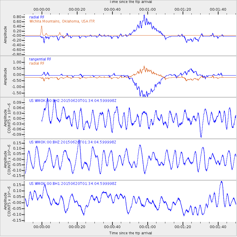
WMOK Wichita Mountains, Oklahoma, USA - Earthquake Result Viewer
*The percent match for this event was below the threshold and hence no stack was calculated.
| Earthquake location: |
South Of Tonga Islands |
| Earthquake latitude/longitude: |
-24.6/-175.6 |
| Earthquake time(UTC): |
2015/06/20 (171) 01:21:21 GMT |
| Earthquake Depth: |
19 km |
| Earthquake Magnitude: |
4.7 mb |
| Earthquake Catalog/Contributor: |
ISC/ISC |
|
| Network: |
US United States National Seismic Network |
| Station: |
WMOK Wichita Mountains, Oklahoma, USA |
| Lat/Lon: |
34.74 N/98.78 W |
| Elevation: |
486 m |
|
| Distance: |
93.6 deg |
| Az: |
53.453 deg |
| Baz: |
242.655 deg |
| Ray Param: |
$rayparam |
*The percent match for this event was below the threshold and hence was not used in the summary stack. |
|
| Radial Match: |
46.53924 % |
| Radial Bump: |
400 |
| Transverse Match: |
44.35734 % |
| Transverse Bump: |
400 |
| SOD ConfigId: |
7422571 |
| Insert Time: |
2019-04-19 09:42:15.617 +0000 |
| GWidth: |
2.5 |
| Max Bumps: |
400 |
| Tol: |
0.001 |
|
Signal To Noise
| Channel | StoN | STA | LTA |
| US:WMOK:00:BHZ:20150620T01:34:04.599998Z | 0.9930595 | 6.872575E-8 | 6.920607E-8 |
| US:WMOK:00:BH1:20150620T01:34:04.599998Z | 1.5987431 | 2.6857387E-7 | 1.6799063E-7 |
| US:WMOK:00:BH2:20150620T01:34:04.599998Z | 0.9746132 | 4.1059252E-8 | 4.2128768E-8 |
| Arrivals |
| Ps | |
| PpPs | |
| PsPs/PpSs | |


