You are here: Home > Network List > UW - Pacific Northwest Regional Seismic Network Stations List
> Station MRBL Marblemount, WA, USA > Earthquake Result Viewer
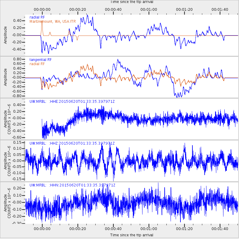
MRBL Marblemount, WA, USA - Earthquake Result Viewer
*The percent match for this event was below the threshold and hence no stack was calculated.
| Earthquake location: |
South Of Tonga Islands |
| Earthquake latitude/longitude: |
-24.6/-175.6 |
| Earthquake time(UTC): |
2015/06/20 (171) 01:21:21 GMT |
| Earthquake Depth: |
19 km |
| Earthquake Magnitude: |
4.7 mb |
| Earthquake Catalog/Contributor: |
ISC/ISC |
|
| Network: |
UW Pacific Northwest Regional Seismic Network |
| Station: |
MRBL Marblemount, WA, USA |
| Lat/Lon: |
48.52 N/121.48 W |
| Elevation: |
75 m |
|
| Distance: |
87.3 deg |
| Az: |
32.621 deg |
| Baz: |
227.586 deg |
| Ray Param: |
$rayparam |
*The percent match for this event was below the threshold and hence was not used in the summary stack. |
|
| Radial Match: |
31.207808 % |
| Radial Bump: |
400 |
| Transverse Match: |
11.141565 % |
| Transverse Bump: |
400 |
| SOD ConfigId: |
7422571 |
| Insert Time: |
2019-04-19 09:42:30.096 +0000 |
| GWidth: |
2.5 |
| Max Bumps: |
400 |
| Tol: |
0.001 |
|
Signal To Noise
| Channel | StoN | STA | LTA |
| UW:MRBL: :HHZ:20150620T01:33:35.397971Z | 0.9717025 | 4.3739618E-8 | 4.5013383E-8 |
| UW:MRBL: :HHN:20150620T01:33:35.397971Z | 1.7030529 | 2.1519627E-7 | 1.2635913E-7 |
| UW:MRBL: :HHE:20150620T01:33:35.397971Z | 1.6174461 | 3.447205E-7 | 2.1312643E-7 |
| Arrivals |
| Ps | |
| PpPs | |
| PsPs/PpSs | |


