You are here: Home > Network List > 7A - Mid-Atlantic Geophysical Integrative Collaboration Stations List
> Station ALMA Alma, West Virginia USA > Earthquake Result Viewer
ALMA Alma, West Virginia USA - Earthquake Result Viewer
| Earthquake location: |
Near Coast Of Central Chile |
| Earthquake latitude/longitude: |
-36.3/-73.8 |
| Earthquake time(UTC): |
2015/06/20 (171) 02:10:06 GMT |
| Earthquake Depth: |
10 km |
| Earthquake Magnitude: |
6.4 MO |
| Earthquake Catalog/Contributor: |
NEIC PDE/NEIC ALERT |
|
| Network: |
7A Mid-Atlantic Geophysical Integrative Collaboration |
| Station: |
ALMA Alma, West Virginia USA |
| Lat/Lon: |
39.40 N/80.84 W |
| Elevation: |
233 m |
|
| Distance: |
75.6 deg |
| Az: |
354.391 deg |
| Baz: |
174.153 deg |
| Ray Param: |
0.05153323 |
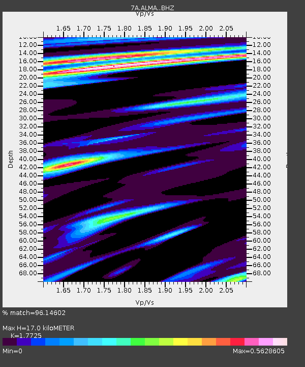
| Estimated Moho Depth: |
17.0 km |
| Estimated Crust Vp/Vs: |
1.77 |
| Assumed Crust Vp: |
6.207 km/s |
| Estimated Crust Vs: |
3.502 km/s |
| Estimated Crust Poisson's Ratio: |
0.27 |
|
| Radial Match: |
96.14602 % |
| Radial Bump: |
400 |
| Transverse Match: |
77.32796 % |
| Transverse Bump: |
400 |
| SOD ConfigId: |
7422571 |
| Insert Time: |
2019-04-19 09:43:47.473 +0000 |
| GWidth: |
2.5 |
| Max Bumps: |
400 |
| Tol: |
0.001 |
|

Signal To Noise
| Channel | StoN | STA | LTA |
| 7A:ALMA: :BHZ:20150620T02:21:20.41001Z | 5.252059 | 4.2345093E-7 | 8.0625696E-8 |
| 7A:ALMA: :BHN:20150620T02:21:20.41001Z | 3.4459846 | 1.9664573E-7 | 5.7065183E-8 |
| 7A:ALMA: :BHE:20150620T02:21:20.41001Z | 1.1718746 | 7.524978E-8 | 6.421316E-8 |
| Arrivals |
| Ps | 2.2 SECOND |
| PpPs | 7.4 SECOND |
| PsPs/PpSs | 9.5 SECOND |


