You are here: Home > Network List > 7A - Mid-Atlantic Geophysical Integrative Collaboration Stations List
> Station PVGR Lower Salem, Ohio USA > Earthquake Result Viewer
PVGR Lower Salem, Ohio USA - Earthquake Result Viewer
| Earthquake location: |
Near Coast Of Central Chile |
| Earthquake latitude/longitude: |
-36.3/-73.8 |
| Earthquake time(UTC): |
2015/06/20 (171) 02:10:06 GMT |
| Earthquake Depth: |
10 km |
| Earthquake Magnitude: |
6.4 MO |
| Earthquake Catalog/Contributor: |
NEIC PDE/NEIC ALERT |
|
| Network: |
7A Mid-Atlantic Geophysical Integrative Collaboration |
| Station: |
PVGR Lower Salem, Ohio USA |
| Lat/Lon: |
39.57 N/81.38 W |
| Elevation: |
0.0 m |
|
| Distance: |
75.8 deg |
| Az: |
353.976 deg |
| Baz: |
173.705 deg |
| Ray Param: |
0.05139114 |
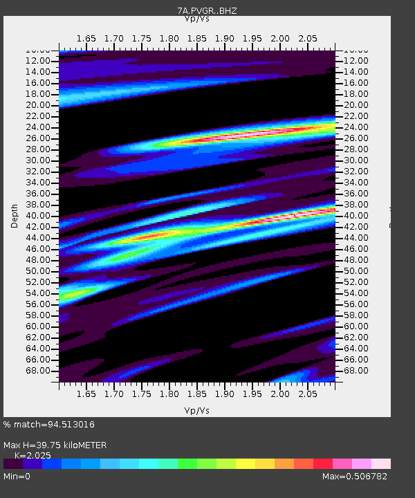
| Estimated Moho Depth: |
39.75 km |
| Estimated Crust Vp/Vs: |
2.03 |
| Assumed Crust Vp: |
6.207 km/s |
| Estimated Crust Vs: |
3.065 km/s |
| Estimated Crust Poisson's Ratio: |
0.34 |
|
| Radial Match: |
94.513016 % |
| Radial Bump: |
371 |
| Transverse Match: |
89.765854 % |
| Transverse Bump: |
400 |
| SOD ConfigId: |
7422571 |
| Insert Time: |
2019-04-19 09:43:56.313 +0000 |
| GWidth: |
2.5 |
| Max Bumps: |
400 |
| Tol: |
0.001 |
|

Signal To Noise
| Channel | StoN | STA | LTA |
| 7A:PVGR: :BHZ:20150620T02:21:21.619971Z | 8.358033 | 6.1996553E-7 | 7.417601E-8 |
| 7A:PVGR: :BHN:20150620T02:21:21.619971Z | 4.0018744 | 2.8352716E-7 | 7.0848586E-8 |
| 7A:PVGR: :BHE:20150620T02:21:21.619971Z | 1.1841317 | 7.614207E-8 | 6.430203E-8 |
| Arrivals |
| Ps | 6.7 SECOND |
| PpPs | 19 SECOND |
| PsPs/PpSs | 26 SECOND |


