You are here: Home > Network List > 7A - Mid-Atlantic Geophysical Integrative Collaboration Stations List
> Station RTSN Coon Bone Island, West Virginia USA > Earthquake Result Viewer
RTSN Coon Bone Island, West Virginia USA - Earthquake Result Viewer
| Earthquake location: |
Near Coast Of Central Chile |
| Earthquake latitude/longitude: |
-36.3/-73.8 |
| Earthquake time(UTC): |
2015/06/20 (171) 02:10:06 GMT |
| Earthquake Depth: |
10 km |
| Earthquake Magnitude: |
6.4 MO |
| Earthquake Catalog/Contributor: |
NEIC PDE/NEIC ALERT |
|
| Network: |
7A Mid-Atlantic Geophysical Integrative Collaboration |
| Station: |
RTSN Coon Bone Island, West Virginia USA |
| Lat/Lon: |
38.94 N/79.58 W |
| Elevation: |
949 m |
|
| Distance: |
75.1 deg |
| Az: |
355.351 deg |
| Baz: |
175.185 deg |
| Ray Param: |
0.051898465 |
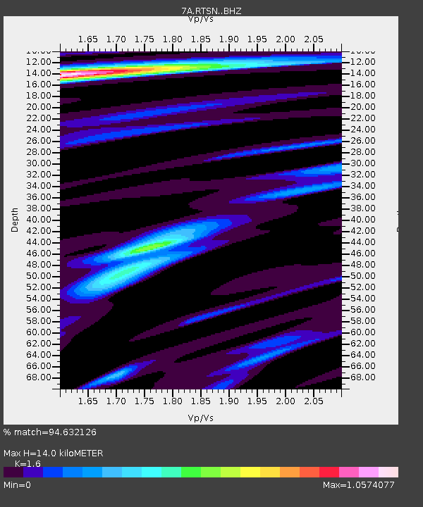
| Estimated Moho Depth: |
14.0 km |
| Estimated Crust Vp/Vs: |
1.60 |
| Assumed Crust Vp: |
6.159 km/s |
| Estimated Crust Vs: |
3.849 km/s |
| Estimated Crust Poisson's Ratio: |
0.18 |
|
| Radial Match: |
94.632126 % |
| Radial Bump: |
400 |
| Transverse Match: |
83.94227 % |
| Transverse Bump: |
400 |
| SOD ConfigId: |
7422571 |
| Insert Time: |
2019-04-19 09:43:56.855 +0000 |
| GWidth: |
2.5 |
| Max Bumps: |
400 |
| Tol: |
0.001 |
|

Signal To Noise
| Channel | StoN | STA | LTA |
| 7A:RTSN: :BHZ:20150620T02:21:17.259985Z | 6.7088103 | 5.034498E-7 | 7.504309E-8 |
| 7A:RTSN: :BHN:20150620T02:21:17.259985Z | 2.917315 | 1.5506653E-7 | 5.315385E-8 |
| 7A:RTSN: :BHE:20150620T02:21:17.259985Z | 0.80153203 | 6.226351E-8 | 7.768063E-8 |
| Arrivals |
| Ps | 1.4 SECOND |
| PpPs | 5.7 SECOND |
| PsPs/PpSs | 7.1 SECOND |


