You are here: Home > Network List > GS - US Geological Survey Networks Stations List
> Station KAN13 Rinehart Farm > Earthquake Result Viewer
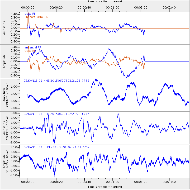
KAN13 Rinehart Farm - Earthquake Result Viewer
*The percent match for this event was below the threshold and hence no stack was calculated.
| Earthquake location: |
Near Coast Of Central Chile |
| Earthquake latitude/longitude: |
-36.3/-73.8 |
| Earthquake time(UTC): |
2015/06/20 (171) 02:10:06 GMT |
| Earthquake Depth: |
10 km |
| Earthquake Magnitude: |
6.4 MO |
| Earthquake Catalog/Contributor: |
NEIC PDE/NEIC ALERT |
|
| Network: |
GS US Geological Survey Networks |
| Station: |
KAN13 Rinehart Farm |
| Lat/Lon: |
37.01 N/97.48 W |
| Elevation: |
340 m |
|
| Distance: |
76.2 deg |
| Az: |
340.684 deg |
| Baz: |
160.506 deg |
| Ray Param: |
$rayparam |
*The percent match for this event was below the threshold and hence was not used in the summary stack. |
|
| Radial Match: |
59.741024 % |
| Radial Bump: |
400 |
| Transverse Match: |
41.068092 % |
| Transverse Bump: |
400 |
| SOD ConfigId: |
7422571 |
| Insert Time: |
2019-04-19 09:46:03.017 +0000 |
| GWidth: |
2.5 |
| Max Bumps: |
400 |
| Tol: |
0.001 |
|
Signal To Noise
| Channel | StoN | STA | LTA |
| GS:KAN13:01:HHZ:20150620T02:21:23.775Z | 3.5872374 | 3.1015963E-7 | 8.646198E-8 |
| GS:KAN13:01:HHN:20150620T02:21:23.775Z | 2.4492145 | 3.8045306E-7 | 1.5533676E-7 |
| GS:KAN13:01:HHE:20150620T02:21:23.775Z | 1.4754223 | 8.871404E-7 | 6.01279E-7 |
| Arrivals |
| Ps | |
| PpPs | |
| PsPs/PpSs | |


