You are here: Home > Network List > N4 - Central and EAstern US Network Stations List
> Station G40A Rib Lake, WI, USA > Earthquake Result Viewer
G40A Rib Lake, WI, USA - Earthquake Result Viewer
| Earthquake location: |
Near Coast Of Central Chile |
| Earthquake latitude/longitude: |
-36.3/-73.8 |
| Earthquake time(UTC): |
2015/06/20 (171) 02:10:06 GMT |
| Earthquake Depth: |
10 km |
| Earthquake Magnitude: |
6.4 MO |
| Earthquake Catalog/Contributor: |
NEIC PDE/NEIC ALERT |
|
| Network: |
N4 Central and EAstern US Network |
| Station: |
G40A Rib Lake, WI, USA |
| Lat/Lon: |
45.27 N/90.20 W |
| Elevation: |
472 m |
|
| Distance: |
82.6 deg |
| Az: |
348.412 deg |
| Baz: |
166.72 deg |
| Ray Param: |
0.046801582 |
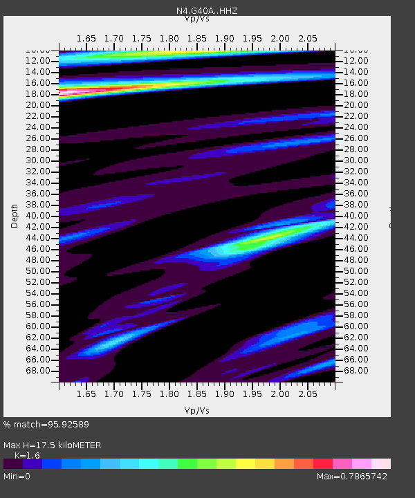
| Estimated Moho Depth: |
17.5 km |
| Estimated Crust Vp/Vs: |
1.60 |
| Assumed Crust Vp: |
6.571 km/s |
| Estimated Crust Vs: |
4.107 km/s |
| Estimated Crust Poisson's Ratio: |
0.18 |
|
| Radial Match: |
95.92589 % |
| Radial Bump: |
400 |
| Transverse Match: |
89.69575 % |
| Transverse Bump: |
400 |
| SOD ConfigId: |
7422571 |
| Insert Time: |
2019-04-19 09:47:16.799 +0000 |
| GWidth: |
2.5 |
| Max Bumps: |
400 |
| Tol: |
0.001 |
|

Signal To Noise
| Channel | StoN | STA | LTA |
| N4:G40A: :HHZ:20150620T02:21:58.209998Z | 6.742535 | 2.8772877E-7 | 4.267368E-8 |
| N4:G40A: :HHN:20150620T02:21:58.209998Z | 3.4686353 | 1.1599862E-7 | 3.344215E-8 |
| N4:G40A: :HHE:20150620T02:21:58.209998Z | 0.9225385 | 3.8700765E-8 | 4.1950297E-8 |
| Arrivals |
| Ps | 1.6 SECOND |
| PpPs | 6.7 SECOND |
| PsPs/PpSs | 8.4 SECOND |


