You are here: Home > Network List > II - Global Seismograph Network (GSN - IRIS/IDA) Stations List
> Station PFO Pinon Flat, California, USA > Earthquake Result Viewer
PFO Pinon Flat, California, USA - Earthquake Result Viewer
*The percent match for this event was below the threshold and hence no stack was calculated.
| Earthquake location: |
Rat Islands, Aleutian Islands |
| Earthquake latitude/longitude: |
52.2/178.1 |
| Earthquake time(UTC): |
2009/10/07 (280) 05:38:37 GMT |
| Earthquake Depth: |
138 km |
| Earthquake Magnitude: |
5.6 MB, 5.6 MW, 5.6 MW |
| Earthquake Catalog/Contributor: |
WHDF/NEIC |
|
| Network: |
II Global Seismograph Network (GSN - IRIS/IDA) |
| Station: |
PFO Pinon Flat, California, USA |
| Lat/Lon: |
33.61 N/116.46 W |
| Elevation: |
1280 m |
|
| Distance: |
49.7 deg |
| Az: |
84.976 deg |
| Baz: |
312.66 deg |
| Ray Param: |
$rayparam |
*The percent match for this event was below the threshold and hence was not used in the summary stack. |
|
| Radial Match: |
54.98653 % |
| Radial Bump: |
400 |
| Transverse Match: |
67.53696 % |
| Transverse Bump: |
400 |
| SOD ConfigId: |
1 |
| Insert Time: |
2010-02-19 00:31:49.545 +0000 |
| GWidth: |
2.5 |
| Max Bumps: |
400 |
| Tol: |
0.001 |
|
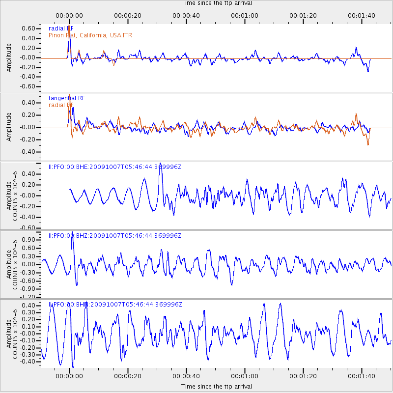
Signal To Noise
| Channel | StoN | STA | LTA |
| II:PFO:00:BHZ:20091007T05:46:44.369996Z | 3.6666238 | 4.9052755E-7 | 1.3378181E-7 |
| II:PFO:00:BHN:20091007T05:46:44.369996Z | 1.5758382 | 2.7152527E-7 | 1.7230529E-7 |
| II:PFO:00:BHE:20091007T05:46:44.369996Z | 2.6036618 | 2.7602061E-7 | 1.0601247E-7 |
| Arrivals |
| Ps | |
| PpPs | |
| PsPs/PpSs | |


